Why...

Two mature aged people who love travelling and learning along the way... Our names are Rob (Robyn) & darian in the 60+ vintage of travellers keen to visit parts of the world which will stretch us mentally, physically and emotionally.

25 July 2009

Iceland 2009

Our High Arctic expedition cruises' final destination was the capital of Iceland called Reykjavík, but before reaching this city, we visited Heimaey, the largest and most populated island off the Icelandic coast where we stayed for 2 nights.
Heimaey Island located south of Iceland
Heimaey became famous in January 1973 when a relentless lava flow from nearby Eldfell volcano destroyed half the town and came close to closing its narrow harbour, its main income source from fishing.
Lava at the back door
The entrance by ship into the harbour is very narrow and it took a massive effort by the town's population using sea water pumped non-stop onto the lava to halt it.
Enterance to Heimaey harbour
We climbed the still active Eldfell Volcano during our stay here and climbed some of the coastline to view one of our favourite birds.... puffins.
Climbing Eldfell Volcano
Heimaey enjoys a very beautiful rugged coastline and abundance of wildlife. We enjoyed observing this as a result of multiple exploration sorties by zodiac around the island.
Cruising the coast of Heimaey Island in a zodiac
Apart from Heimaey Island there other islands nearby as part of the Vestmannaeyjar archipelago, home at this time of the year to literally millions of seabirds like Guillemot, Manx Shearwater, Auks and Northern Fulma to name very few.
Small island off Heimaey covered in nesting seabirds
As we cruised the coastline, we were also lucky to be able to follow in the zodiacs, a family or pod of Orca (killer whales) as they majestically cruised the ocean and exerted their presence on everything, including us.
Following males and female orca in zodiacs
After reaching Reykjavík and bidding farewell to our fellow 'expeditioners', the fabulous guides and Russian crew we picked up a rental car and started our exploration of Iceland as the map below shows.
Route around part of Iceland
Let me say up front that after visiting Iceland... it is definitely a country we want return to and see a much more of it because of its natural rugged beauty in so many ways.
Rugged southern coastline of Iceland
Iceland sits just outside the Arctic Circle which passes just north of the island and is a country with a very rich Viking derived history and culture and is home to over 300,000 very friendly residents.
Looking into viking history at Amarstapi
Old flow of lava now covered by very spongy moss
Iceland is also home to numerous very active volcanoes which have over time created the dramatic landscapes constantly visible once you leave the city.
Lava formed rock on coastline
Through Iceland passes one of the world's major fault lines separating the American plate from the European plate and the fault line is large enough to walk through, which was a little unnerving.
Rob looking into the fault line
The island is also the location of the original geyser, in fact we visited the town of Geyser to visit THE geyser and watch it erupt on a very regular basis.
Geyser going...
...going
...gone!
Located where it is in the far north of the planet also means Iceland is home to some of the largest glaciers in the world...
Can you spot the people on the glacier
and with glaciers come two other sights in the form of small icebergs calving into a lake in the south of the island and...
Small icebergs from Fjallsarlon glacier
waterfalls, quite a few famous and very beautiful waterfalls.
Skogafoss waterfall 
Gullfoss waterfall
All this thermal activity within the island allows Reykjavík to run on geothermal power and our last destination on Iceland as we headed to the airport for our flight to London is a result of that power generation... the world famous Blue Lagoon.
The Blue Lagoon, Iceland
Here we thoroughly enjoyed a very relaxing swim in the warm waters of the lagoon pondering the trip that was and the amazing experiences we had, and we will be back!

20 July 2009

The High Arctic 2009

The time had arrived for us to do something very different indeed as we boarded the Boeing 737 for our flight out of Tromso Norway, heading further north and to the west to Spitsbergen, the largest and only permanently populated island of the Svalbard archipelago north of Norway.
Flight from Tromso, Norway to Longyearbyen on Spitsbergen Island
Flying across Svalbard
Longyearbyen is the only town in the archipelago and is the northernmost city in the world and was founded in 1906 when it was established for mining by an American.
Longyearbyen and mining gantries
There are about 2,000 residents in the city and it is very novel due to its location.  

For example, the mines still operate with gantries built throughout the city transporting buckets full of coal to the port.

We stayed in a very nice hotel and within the city are some very good restaurants to enjoy.  If you leave the city limits, by law you are meant to carry a firearm because of the risk of being attacked by any of the 3,000 polar bears on the island.

We were here for 2 nights to do a little sightseeing around the town, including going on 'sled' ride around the outskirts, the sled having wheels because of the lack of snow, but still pulled by a team of huskies.
The primary reason however for being here was to board the ice-hardened Russian expedition ship called the Akademik Ioffe, one of 2 sister ships allegedly used for sending and receiving sonar signals whilst searching for US nuclear submarines.
Akademik Ioffe - 'home' for 12 days of expedition cruise
We boarded the ship, along with about 65 other passenger, almost half the normal number due to the impact of the GFC and met the guides who would be looking after us for 12 days of expedition cruising.

Our route over the next 12 days as shown in the map involved exploring around the coast of the archipelago, including sailing above 80 degrees latitude or 885kms from Nth Pole, before turning west to Greenland for more exploring and then sailing south to finish in Iceland.
Expedition cruise route
Cruising the Spitsbergen coastline 
Each guide is a specialist in something, for example - photography, marine biology, geology and history.  

Some were professors and some highly acclaimed professionals who all simply enjoy being in the Arctic.

Expedition cruising means literally exploring places which take the guides interest by poking the ship into bays before boarding rubber zodiacs to explore whatever was nearby.

Remember though, we were on an ice hardened ship for a reason... ice, lots of it either in the form of sea ice as we cruised almost anywhere this far north, ice near the shore when undertaking landings on land by zodiac and of course... icebergs.
Our ship nudging its way through sea ice
Our main reason for being on this trip was to experience something totally different, which it surely was, to see the ice and icebergs and wildlife, especially polar bears.

Our expedition journey was a resounding success as hopefully the following few pictures attest to as should some additional photos in the link at the end of this post.
Watching a young polar bear searching for eggs
Walrus less than 5m from the zodiac
Cruising amongst the icebergs
Humpback whale joining us next to the ship

Polar bears are big... very big
Arriving on the coast of Greenland included a visit to a community who had not seen a ship for 18 months, and it was great to talk to the locals about their way of life.  

"Have you noticed climate impacts at all?" I asked a 80 yr old matriarch.  

"Sure, plenty, its much easier to dig graves now, the permafrost is lower" came her reply.

These Inuit people are allowed to hunt for a specific number of polar bear each year as they have done for centuries and everything is used in some way as a part of their culture.

Its a tough environment to live in and extremely remote but the country and scenery is serene, quiet and spectacular.
Truly remote living
Outside frozen loo with a view
The final leg of our expedition involved 2 days sailing south to the island of Iceland, more of which will be described in the next post.

If you would like to see a few more photos of our travels in the high Arctic, simply click on the link below:

CLICK HERE for more photos of High Arctic 2009

Until next time.... go well!


7 July 2009

Norway 2009

Norway is a country we had been looking forward to visiting for a very long time and during our planning for this trip, you quickly understand it is also a very expensive destination, even more so than Denmark.

As a result we decided to use various forms of transport to get to and around Norway, hence the ferry from Hirtshals in Denmark, but we also used trains, buses, boats and planes and the map below shows our entire journey through Norway.
Boats, trains, buses and planes through Norway
Coastal ferry trips from Denmark to Bergen, Norway
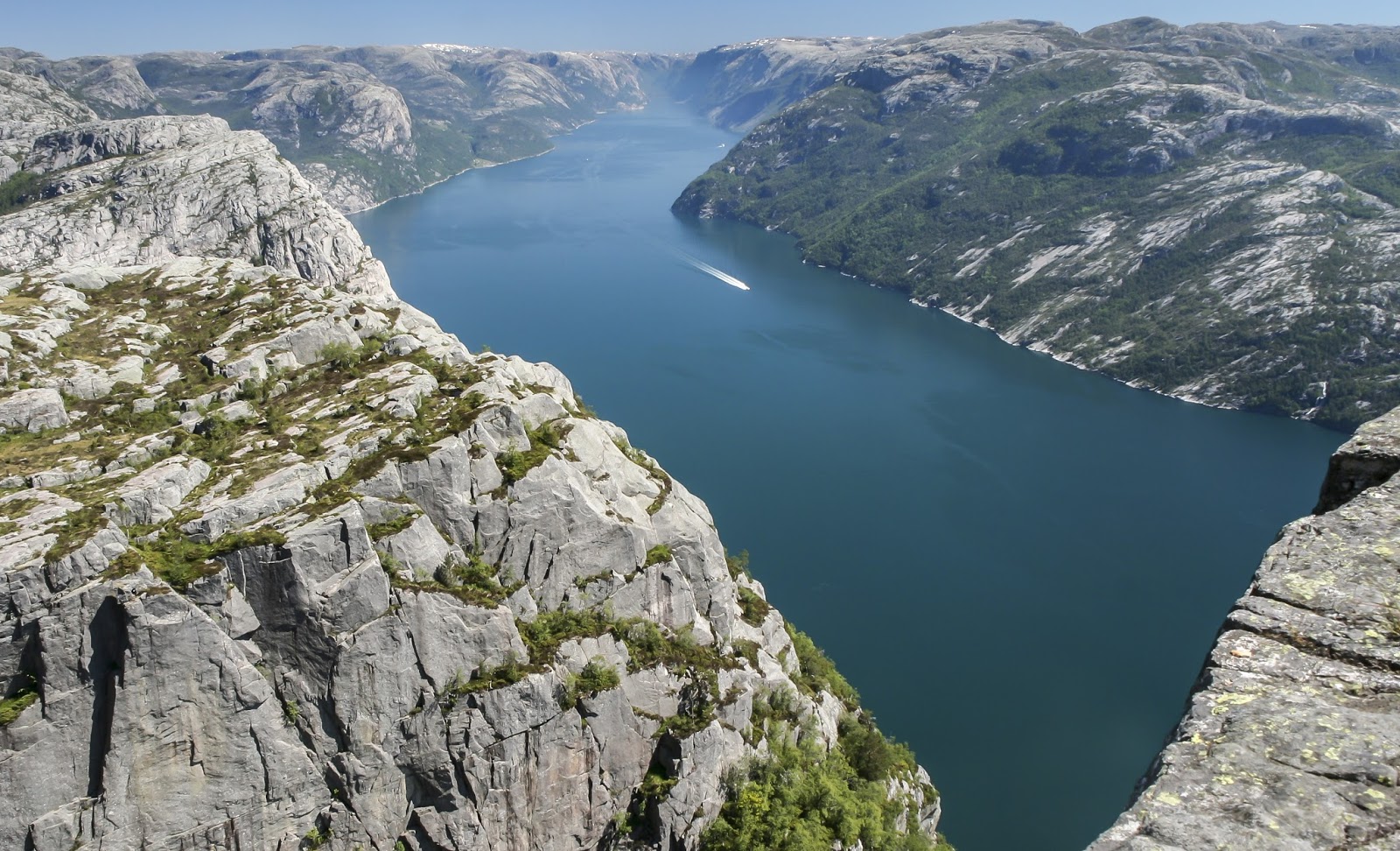
Pulpit Rock, Norway
The first ferry from Denmark to Stavanger was a fabulous way of seeing some of the beautiful coastline of Norway, the scenery very different from the flat form of Denmark.

Whilst in Stavanger, we took a bus to go on a hike, a 3hr hike... actually more like a climb and fortunately in clear and warm weather, as our destination called Preikestolen is renowned for being in fog or clouds frequently. 

Whilst at times this was a reasonably tough hike clambering over rocks, the final result was well worth it.

Preikestolen, also known as the Pulpit Rock, in Ryfylke in Rogaland is a flat plateau of about 25 by 25 metres, which rises 604 metres straight up from the Lysefjord fjord. 

From here, the rock disappears vertically below you and if you sit right on the edge there are fantastic views of the waters below and the Lysefjordheiene mountains.


Admiring the view from Pulpit Rock
View down the fjord from Pulpit Rock
After another very interesting coastal commuter ferry trip stopping at multiple small towns, we arrived into Bergen founded about 900 years ago during the viking era.  
Coastal town on the way to Bergen
There is much to see and do in and around Bergen, which also enjoys a vibrant atmosphere.  This very urban city of ~280,000 is one of Norway's most visited destinations because of its own scenery as well as its proximity to some of Norway's largest fjords.
View of the city centre from Mt. Fløyen
One of the city's most visited areas is the World Heritage area of Bryggen, an old town section with many brightly coloured timber buildings used in the past for trading.  Most of the buildings over the years have been destroyed by fire and rebuilt.
View of historic Bryggen back to Mt. Fløyen
But the nearby fjords beckoned, so with luggage in tow we took a boat tour to view the fjords before catching the famous Flam railway towards Oslo.
Water level view of the Norwegian fjords
We didn't spend much time in Oslo, not because it isn't a nice city, but simply because we were about to head into the arctic circle to stay on a small chain of islands we learned about from a Norwegian work colleague called the Lofoten archipelago.
The VERY beautiful Lofoten archipelago
After flying into Svolvær, we picked up our 'rent a wreck' and went searching for the accomodation called a rorbu, which were originally huts used by cod fisherman venturing into this region of the Norwegian coast.

Rorbuer (plural) are all painted red, are quite small with low roofs and ceilings but were very comfortable, cosy and quaint.
Around Svolvaer and the bright red rorbuer
This place is just amazing from a scenery point of view, with towering jagged mountains right next to the ocean, small islands visible everywhere and incredibly clear seawater supporting the growth of not just the fish but the seaweed and shell fish covering the rocky shores as far as you can see.

Our rent a wreck actually got a lot of use because you can drive the complete length of the island chain and the scenery everywhere was just breathtaking and this part of the world soon reached one of our very few - 'must visit again' destinations!
Near the southern end of Lofotens in small town simply calleÅ 
Cod drying on racks
More of Lofoten's stunning scenery
I could go on and on about this part of Norway because of its beauty, but time for another boat trip, this time overnight, further north up the coast on a ferry called the Hurtigruten cruise line.  These are big, comfortable ships which travel the entire length of the coastline carrying tourists, cars and goods for local communities.
Hurtigruten ship at Lofoten Islands
From the map you can see where we had been and where this vessel took us, Tromso, 350kms north of the Arctic Circle and near the very top of Norway and as a result, significantly colder than anywhere we had been so far.
The route to Tromso, well into the Arctic Circle
Tromso is a small city with a population of ~50,000, including a large proportion of younger people attending universities in the area.
View of Tromso from Storsteinen mountain ledge 
It was in Tromso we discovered just how expensive Norway could be when we went searching for dinner.  The prices on menus outside a few restaurants were simply crazy, so we had a look at a burger place similar to Hungry Jacks and the total for 2 meal deals was $60 AUD.

But we weren't in Tromso to spend too much time here, it had been the end of the rest of a wonderful trip through Norway and where we needed to catch a plane to the most northern city in the world, to then join an expedition boat for our next adventure.

So until our next post.... go well!