This is a trip along an unknown route heading north-ish into what is known as the ‘gulf country’ at the top of Queensland (QLD). Had thought about heading also into the Northern Territory (NT) and maybe down through the centre of Aust. to South Australia (SA) before heading back home.
Sudden intra Australian border closures due to the ongoing Covid dilemma had created too much uncertainty. Covid has triggered some States to close borders between each other and forced people wanting to enter those States, like ours, into hotel quarantine for 14 days at your own cost.
For example, if we were driving in the ‘wrong’ State and had to come home suddenly, we would have to store the car and caravan in that State, fly home and quarantine for 14 days. We are not allowed to drive back across the border. Great hey!
Duration of this trip could have been as long as 3 months but it depended on how hot it got once the wet season started and how much fun we were having. La Nina and the whatever Indian Ocean dipole is, was causing forecasters to advise of a likely early start to both the wet and cyclone seasons.
So in summary, the two of us simply intended to go where the mood took us and stay as long as the mood kept us.
Part of this included tapping into the bush telegraph network for tips on new places to explore by learning about other traveller’s experiences.
Our intention was also to spend more time free camping, combined with enjoying the additional benefits of caravan parks like washing machines or swimming pools or the rusticity of cattle stations where that’s appropriate.
For the uninitiated, free camping simply means staying where there are no charges to camp at that location. Typically there might be a public toilet available but there is no power or showers available. Sometimes there may be drinking water but not usually.
Free camping and other locations can be found using dedicated books or the Wikicamps app. and we use both because not all spots are in both sources. Additionally, we might also just find our own spot, especially if only needing an overnight stop.
Below is an general map of where we actually travelled, to provide a feel of our overall route, but for this post(s), will insert more detailed maps progressively throughout it, so more specific locations of where we stopped can be related too.
 |
| The red lines show where we went totally within Queensland during this trip, a total of 7,400 kms |
It quickly became obvious there were a LOT of people travelling within QLD due to Covid, many of them originating from other States like Victoria when our State briefly opened its border and they charged in. We seldom were alone no matter where we chose to stop.
 |
| First night camping near Kilkivan |
Okay… enough preamble chatter, where did we go and what happened.
The early parts of our travels were quite straight forward as we decided to free camp typically for a few nights at either dams or on the banks of rivers.
 |
| Everything was very straightforward from home to Barcaldine allowing us to really get into the groove again |
There are some very nice places to stay and we only selected a few as shown below, but there are so many more when you put in the effort to find them using the resources mentioned earlier.
 |
| Wuruma Dam had LOTS of Victorians camping near it so they could fish and socialise with each other |
 |
| Free camping in an Apex sponsored park with many others near Moura |
 |
| Kookaburra at Moura and they are smaller than southern variety and are different with the flashes of blue on them |
 |
| Free camping on river next to Jericho with sun setting, fire going and some wine to enjoy... perfect! |
These stops also got us back into the ‘groove’ as we refined how things were packed in both the car and the van.
When we reached Barcaldine, the nature of our camping changed a little, in part due to changes in the weather and as we selected places to visit based on the growing input from other travellers.
When we visited and enjoyed the hot artesian water filled baths at Charlotte Plains cattle station, another traveller told us about a station called Lara near Barcaldine and its camping area called Lara Wetlands and it was here we based ourselves for 5 eventful nights.
 |
| Barcaldine is home to the tree of knowledge and location where Australian Labour Party formed after strike nearby by shearers in 1891 |
 |
| Where we set up to camp on the edge of Lara Wetlands very close to the edge of the lake |
Lara Wetlands is very popular with young families, so they tend to keep all the kids near each other in one section next to the lake, so we went to the other end.
Early morning after our first walk around the lake, we sat in the thermal pool for awhile before heading back to our camp for breakfast, a truly lovely way to start the day and socialise with other campers, along with tapping into the travellers bush telegraph.
 |
| Rob having a soak at 7:30am after our walk around the lake |
Also scattered around the edges of the lake are small toilet and shower facilities and the showers only have hot water twice a day after the donkey hot water system is fired up.
A donkey hot water system consists of a 44 gallon drum heated from below by a wood burning fire. Cold water is fed into the bottom of the drum, the flames heat the water which rises to the top of the drum and is piped into the showers as a constant cycle.
The lake is not very deep, perhaps an average of 30+ cms, especially at this time of the year, and throughout the lake are scattered dead trees with their twisted gnarly grey limbs making interesting shapes and homes for a variety of birds.
 |
| One of many dead trees in the lake |
 |
| Pair of galahs enjoying natural perches |

 |
| Small selection of the abundant birdlife on or near the lake |
 |
| Water colour effect of Rob kayaking on the lake |
 |
| Out on the water in amongst the dead trees |
They even supplied small fire pit drums, scattered randomly around the lake for those campers who enjoyed having a fire to cook on, or simply stare into at night as the stars and moon appeared.
At our age you may have thought that would have been eventful enough, but no, there was more to come as mother nature intervened… twice.
In this part of QLD there are only two seasons, the dry and the wet and we were nearing the end of the dry, hence the reasonably shallow lake, despite being constantly topped up by the artesian water flowing from the thermal pool.
It is also typical at this time of the year as the season changes for localised thunderstorms to kick off, which they did over our part of QLD for an entire day, with constant grey clouds, lightning and large bursts of rain, with up to 50mls of rain in one day making its presence felt everywhere.
 |
| The storm clouds forming before the skies opened up |
 |
| New temporary lakes formed during the day |
 |
| These campers stepped out into water next morning |
People camping near us were flooded as a small lake formed directly outside the doors of their vans and as we walked around the lake, people in tents were trying to move to higher ground, some vehicles were bogged, but most people were making the most of the situation.
Some campers left early the next morning after the rain stopped and promptly got bogged in a patch of a black soil section of the 15km track back to the main road. Station workers came in to help get them out but the managers quickly asked other travels intending to leave to stay for an extra day/night for free so things could dry out a bit first.
 |
| They didn't think it was a laughing matter either |
People started sprinting to their vans to try and get awnings down, which we managed to do, when the full force of the gale blowing the dust hit everyone. As the dust cleared, behind it were darker clouds and gloomy skies as the sun set and none of us expected to see what happened about 20 minutes later… the most stunning sunset during our stay.
 |
| Simply stunning |
Next morning we did our normal walk around the lake and as we neared the thermal pool where families camped, we came upon some disturbing sights. A caravan had lost its awning after the wind flipped it up and over the van and then, we reached a tent which had been crushed by a large falling tree branch.
The local scuttlebutt told us a family of 5 who were in the tent at the time, were all okay and had gone back into Barcaldine to stay with friends.
it had been an interesting stay in a fabulous location as we made our way back along the 15kms of dirt road, including having to use a new track created by the Station to let travellers come and go more safely.
Both at Lara Wetlands and Jericho, we had heard from other travellers about something called ‘the sculpture trail’. To experience it we had to return via Barcaldine then head north to a small town called Aramac before then going another hour to the northeast to reach Lake Dunn.
Aramac is one of the oldest towns in the central west of Qld and is where the infamous Harry Redford (Captain Starlight) was a drover and cattle duffer who stole 1,000 cattle from the Aramac area and drove them 1,287 kms in 3 months into South Australia to sell them.
Among the cattle he stole was a white bull from Bowen Downs Station which nearly proved to be his undoing when it was identified, a statue of the white bull now having pride of place in Aramac’s main street.
 |
| The white bull of Aramac but there are many other smaller steers located around the streets of Aramac |

 |
| Campsite and view to the water at Lake Dunn |


 |
| The sculptures were very cleverly made and told their own stories about life and the character of the bush |
 |
| Wally was hiding behind a tree |
 |
| Leaving Barcaldine we travelled via Longreach for lunch, stopping overnight near the highway before reaching Winton next morning |
Everyone attending had to register and wear a wrist band as part of the towns ‘Covid Safe’ plans. The range and volume of opals on display was immense.
 |
| Main street of Winton with opal festival underway |
Winton had a very nice feel to it with many old historical buildings and bush style sculptures scattered throughout the centre of the main street… very cool indeed.
 |
| Some of the artwork scattered through Winton |
We ventured south of Winton to go camping in Bladensburg National Park, originally established by pastoralists, but also the site of a reputed massacre of aboriginals at Skull Hole. The park is located in what is known as the channel country and does have a few permanent water holes which draws in wildlife.
 |
| Camp set up in Bladensburg Nat. Park |
 |
| Gum trees next to creek bank during sunrise in Bladensburg |
 |
| Rainbow bee-eater in Bladensburg Nat. Park |
 |
| Birds enjoying waterhole in Bladensburg |
Camping together not far from us in tents were 2 families with kids and as happens, when one of the mothers walked past us, we got into conversation about respective travels and sharing experiences.
 |
| Historical cattle yards in Bladensburg |
When the dust storm and associated strong winds hit, their tent was being lifted on one side so the husband got their whole family already inside the tent to sit on that side to hold it down.
It was a stroke of absolute fate that the tree fell onto the section of tent they were no longer in moments earlier, the tent crushing in and scaring the wits out of them. Also luckily for them, good friends live in Barcaldine and it was there they went to recover before continuing their holiday with those same friends. Quite a story to share and a reminder of how things can change very quickly.
 |
| Our route from Winton to Adeles Grove |
Before reaching our next destination where we would stay for awhile, we stopped overnight out the back of the pub in Mckinlay, a very small town with a population of <200 residents, but the pub was the main reason for staying.
 |
| Walkabout Hotel in Mckinlay at sunset |
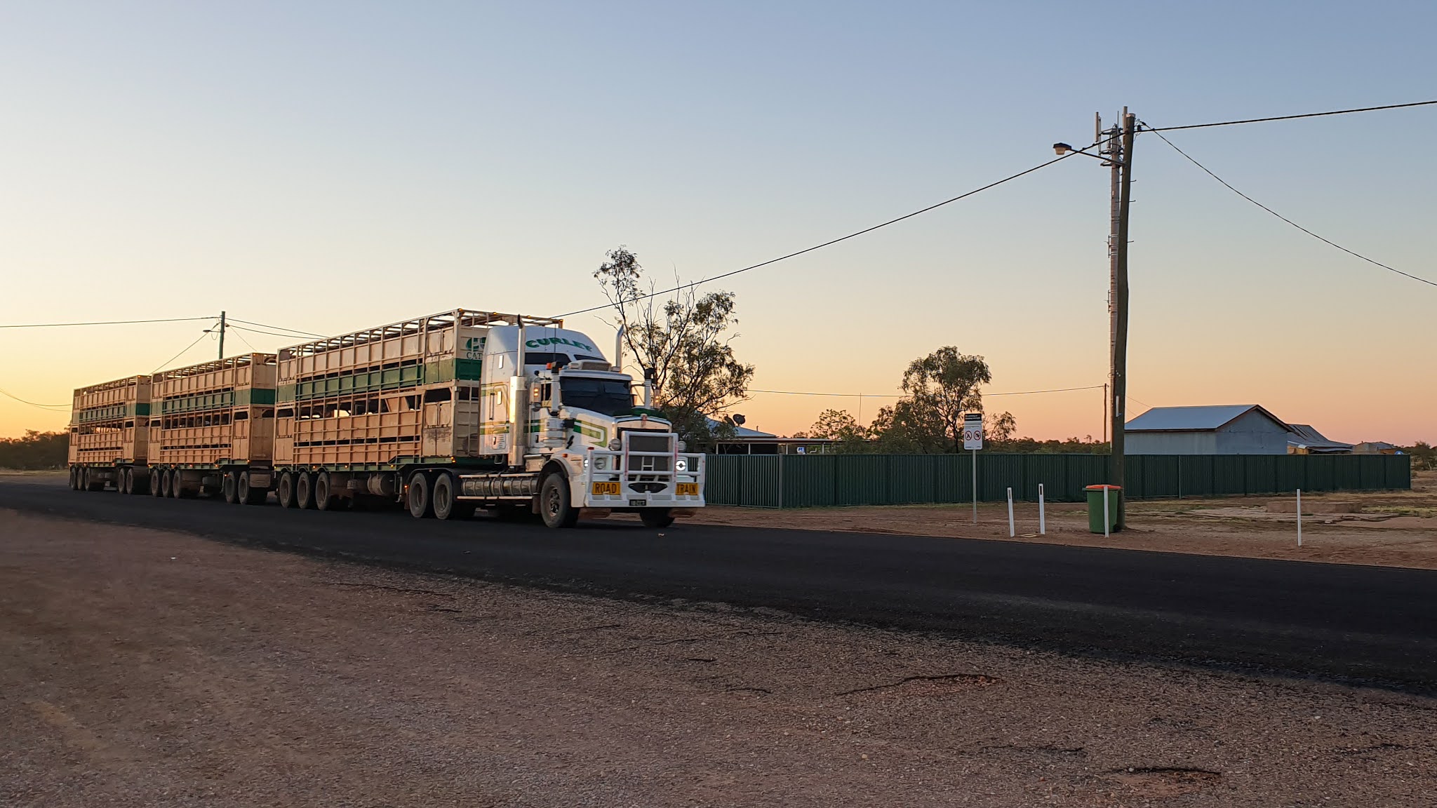 |
| Cattle road train passing Mckinlay Pub |

 |
| Actual bar made for the filming of Crocodile Dundee |
 |
| Real front bar of the Walkabout Hotel |
There are dirt tracks around much of the edge of the lake and all we needed to do was try various tracks to find a location which suited us to set up on, and again stay in this case for 4-5 days. We were not alone as its a very popular destination for ‘grey nomads’ each year but this year it was especially busy.
 |
| Our campsite on edge of Corella Dam |
 |
| View from under our awning overlooking the water and other campers |
 |
| Other views around sunset were pretty neat also |


 |
| Some of the wildlife found around or into Corella Dam |
For a few days, we could see near a very distant shore of the lake, flocks of pelicans and cormorants seemingly enjoying each others company, but whilst sitting outside under the van’s awning enjoying breakfast, a flotilla of them decided to make a visit.
Hundreds of cormorants descended onto the water directly in front of us and immediately starting diving underneath for fish. Behind them came the pelicans, descending gracefully like flying boats in amongst the feeding frenzy. It was quite a sight as we rushed for the camera and tried to capture the spectacle happening on our ‘doorstep’.
 |
| First the cormorants flew in |
 |
| Then the pelicans landed in amongst the cormorants |
 |
| Feeding underway |
Our whole time however wasn’t spent lazing around the waters edge because we did go exploring the remains of the Mary Kathleen township, first settled in the 1960’s and a location we had camped in 30 years previously.
The remains of the housing blocks, low brick walls and drive ways still remain as a ghostly reminder of a once thriving town, as does the massive hole they mined uranium out of from 1956 until it closed first time in 1963 before reopening in 1974 until the uranium reserves were depleted in 1982 and the mine and town were closed for good.
| Deserted house site at Mary Kathleen |
 |
| View over Mt Isa and its famous large chimney stack |
The shopping rush was on as it was for many others, because we were leaving on Tuesday to go further north. The hot weather also meant we used the parks pool… a LOT... in between having a good look around Mt Isa and its surrounds like Lake Moondarra, a popular picnic, fishing and boating destination for the locals.
 |
| In more remote and hot places like Mt Isa a large lake like Moondarra is needed for recreation and to cool off |
We did have company next to our van in the form of a bower bird, diligently collecting objects from the surrounds and fastidiously locating them very carefully within its tunnel shaped bower. It was fascinating to watch him and he got very excited when a female visited to see how everything was coming along.
 |
| Male bower bird stands proudly in front of its decorated bower |
Now fully loaded with fuel, food and water, we were set to hit plenty of dusty, rough dirt roads to re-visit some places first visited during our trip around Australia as a family in 1990. Before reaching Camooweal about 190 kms north west of Mt Isa, we turned north for awhile until we hit the dirt and reduced tyre pressures.
Our goal was Adels Grove, but before reaching it we took the road taking us across a few flowing creeks and into Riversleigh, a UNESCO world heritage site, renowned as one of the most significant fossil sites in the world with objects dating back 25 million years.
 |
| One of the few creek crossings on the way to Riversleigh fossil site |
 |
| Overlooking Riversleigh world heritage fossil site... very dry and barren, our car and van a speck in the middle of the picture |
 |
| Some 25 million year old fossils embedded in rocks |
 |
| Models of some of the ancient fauna found in the area millions of years ago |
Adels Gorge is located about 15 kms from Boodjamulla and the gorges, has camping in amongst the trees in an area called ‘The Grove’, and located right next to the beautiful Lawn Hill Creek with its refreshing waters which we enjoyed swimming in multiple times a day.
 |
| Camping site amongst the trees at Adels Grove |

 |
| Two of the swimming holes very close to our camp in Adeles Grove We camped in amongst the trees after picking a location we hoped would provide enough sun to let our solar panel keep charging batteries in both the van and car enough to keep fridges going in both for 4 days. |
We visited Boodjamulla and its lovely gorges twice to do some of the walks it offers and after a very early morning walk, to go canoeing through the main gorge until we reached the small waterfalls releasing water from the more small gorges above them.


 |
| Some of the scenery within Boodjamulla (Lawn Hill Gorge) Nat. Park |
We were the only people on the water as we glided past towering cliffs at times on both sides of us, whilst admiring some of the wildlife or trees clinging to life on the sheer red rocky walls.
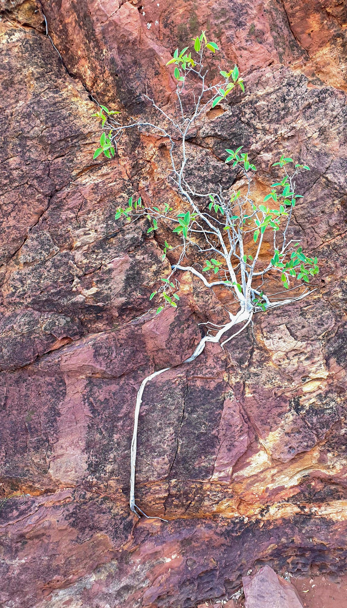 |
| Tough for some trees to stay alive |
 |
| Plenty of dirt road driving from Adeles Grove to the mouth of the Gulf of Carpentaria at Karumba Point |
Taking a different rough dirt road from Adels Grove, we now bumped our way east towards Gregory, a long plume of dust billowing out from behind our van. Slowly but surely, we were catching another traveller heading in the same direction, his tell tail dust trail growing ever larger.
Once we were close enough to pass them, we tried talking to them on our UHF radio to let them know we wanted to come by. No response, so I turned on our headlights but they showed no sign of even knowing we were there. Next we moved right over to the right hand side of the road to make it even easier to see us and flashed our driving lights a few times, all the time slowly getting closer. Still no reaction!
Finally we both reached a cattle grid across the road to cross and he slowed, we think now spotting us still over on the far right hand side of the dirt road and slowed down. We slowed down enough to still pass but enough to try and stop rocks flying off wheels to hit their car and camper trailer.
As we went passed we were greeted with a white haired man yelling at us through his open window. Hmmm… not sure what he expected us to do except limp along behind them in their dust for an hour or so but opening his window to yell at us simply meant he was going to cop a lot of dust into his car. Oh well!
The small town of Gregory only has a population of 70+ people but it does have an old pub and a great free camping spot next to the permanent spring fed cool water of Gregory River, another perfect place to lie in under stately trees trying to get relief from the 39c heat.
 |
| Rob cooling off in the water of Gregory River |
Again 30 years earlier we camped here for a few days and again we enjoyed a meal in the pub, still run and owned by the same person we originally met.
 |
| Gregory Hotel and people socially distancing even out here |
The story goes that the water feeding this river originates in the mountains of Papua New Guinea, travelling underground to Australia and being a permanent source of water, also meant there was a lot of wildlife to try and photograph.


 |
| Wildlife enjoying permanent source of water at Gregory River |
 |
| Some of the stories told via the graves in the Burketown cemetery |

 |
| Colourful artesian bore in Burketown |
 |
| Driving across the huge clay-pans north of Burketown |
We didn’t go any further to avoid getting bogged, but did return later that afternoon after meeting some dingo pups in town to join an indigenous run astronomy tour.
It was quite surreal standing way out on the clay pans in the pitch dark, listening to stories about the dreamtime and their connection to the stars spread out above us. We also got to look at Mars, Saturn and other stars through a large computer controlled telescope.
 |
| Rob meeting a dingo pup |
 |
| Indigenous astronomy guide sharing dreamtime stories linking their beliefs and culture with the stars in front of totem symbols |
 |
| Our milky way whilst standing on the clay-pans outside of Burketown |
As we continued our travels even further north east on both bitumen and dirt roads travelling through some stunning landscape near Leichhardt Falls, named after the famous explorer who perished in our outback in 1848.

 |
| Exploring Leichardt Falls |
We also stopped briefly at Burke & Wills Camp 119, their last camp before the two explorers tried to reach the Gulf on 12 February 1861. The mangroves and mud stopped them reaching the sea, but they did taste the salt water and watched the tide change across the mud flats.
Before they left the camp on 13 February 1861, 15 trees were ‘blazed’ in a rough circle with axe markings to signify they had been there. There are virtually no remains of the trees but there are concrete markers showing where they were. We visited the same location in 1990 but here were no displays or markers, just the trees.
 |
| Blazed tree with marker at Camp 119 |
 |
| Explanation of historical tree blazing 'norms' |
 |
| Termite mounds next to road |
 |
| The fabulous Purple Pub in Normanton |
We stayed a few days in a caravan park which had a pool which was great to cool off in, but also because we were well and truly in crocodile country, something we were reminded off whilst looking at the life size model of the 8.63m croc shot nearby in 1957, one of the longest ever recorded worldwide.
 |
| Rob in front of life size model of huge croc shot near Normanton in 1957 and we are certainly now in crocodile country... no more swimming in natural water! |
 |
| The story of the monster croc |
Normanton is also home of the old but famous tourist Gulflander Train which still travels each week between Normanton and Croydon and was created after gold was found in the area in 1868.
In 1990, Rob and the kids ‘enjoyed’ a short ride on the train and now it was my turn. The 30 tonne train is a 1956 motor-rail model which simply means it uses a truck motor to drive it and the driver has to change gears to maintain speed.
 |
| Gulflander emerging along its very old train line |
I had to catch the returning train at Critter Camp located about 25 kms down the line towards Croydon. If you are looking for a smooth journey, definitely don’t catch this train, but if you want a unique trip and kidney massage, then this is the train for you. The track has lots of buckles in it and is laid on the original steel sleepers which were simply placed on the surface of the soil.
 |
| Original steel track and railway sleepers laid directly onto the ground |
 |
| The Critters Camp station where I caught the Gulflander |
 |
| Hanging out of the Gulflander ready for a bumpy ride |
 |
| Socially distanced inside the Gulflander |
You do get to see some country not visible from the road, along with getting a profound sense of what happens when there is a big flood out here during the wet season when water would have been above the top of the train carriage.
 |
| Very desolate country waiting for the wet season to start |
Believe it or not, we had to negotiate a gentle 2km climb onto a plateau before reaching Normanton and the driver missed a gear before starting it, so it was a long jolting ride back to the station where Rob was waiting and it was quite an experience overall.
 |
| The Gulflander's station in Normanton |
 |
| Burnt out remains of a brand new caravan |
The bush telegraph later told us a couple travelling towards Normanton experienced a battery failure inside their van and it caught on fire. They panicked and neglected to disconnect their car from the van and the fire ended up consuming the whole lot… holiday over!
Karumba point sits right on the waters of the gulf and is a renowned destination for Victorian grey nomads especially, who come and stay for a few months every year to go fishing during the day and watch the sunsets over the ocean.
The sunsets were spectacular each night during our stay after spending the hot daytime hours exploring nearby.

 |
| Pub at Karumba Point was a great place to enjoy a meal and watch the sunsets over the waters of the gulf |
Having reached our most northern destination goal it was now time to turn east and head for the coast as we started our journey back home to be covered in ‘Part 2.’ of FNQ.
 |
| Cheers! |
CLICK HERE for more photos of FNQ Part 1.
Till next time... go well!