During most trips we have, there is usually a place which creates lasting memories either because of some extraordinary experience, or it’s something we didn’t expect, or maybe something very amusing happens etc etc etc.
Well… Yakutat is that place, so apologies up front, this post isn’t a short one.
The first of the trip maps below shows us leaving Anchorage for the last time and travelling roughly 590 kms via Cordova to a very small town called Yakutat in Alaska.
We wanted to experience something different in Alaska and from the very first step onto the plane for our flight to Yakutat, until we stepped onto the ferry to leave 3 days later, Yakutat simply overwhelmed us with experiences!!
After boarding, we learnt for the first time that we were on a milk run flight to Yakutat via a place called Cordova, Alaska. When we landed there and some people disembarked, the rest of us had to stay onboard, the plane was a about 30% full. One of the flight attendants having noticed our accents, wanted a chat whilst we waited, so we asked her, “what is there to do in Juneau?”.
She recommended something, but then the person behind us offered an idea, then someone a few rows forward came up with something and before long, most of the people on board were joining in and even debating amongst themselves whether something was worth doing or not. The waiting time flew by and we were already off to an interesting start to this leg of our trip.
As we walked across the tarmac after our landing into Yakutat, we were greeted by dense low cloud, drizzling rain and dim grey light. We were staying at a place called Leonards Landing Lodge and Rochelle was waiting to take us there via one of 2 grocery stores to pick up basic supplies because our accommodation had cooking facilities and there aren’t many places to eat out in Yakutat.
In the grocery store we met one of the locals who asked if we had been in Yakutat long and “are you here to fish?”. She was very surprised with our reply, “no, we’re not fishing, just here to look around”. Yakutat is usually a place people go to go fishing and is the smallest town in Alaska to be serviced by a daily jet service, mainly to freight peoples frozen fish back out.
So we climbed into some sort of old ‘yank tank’ with wide seats we immediately sank right down into, seat belts that either didn’t work of just weren’t there and headed off with about 5 of the 8 cylinders working. Now Rochelle is fairly short and barely could see over the steering wheel but did manage to wave to every other driver and pedestrian we passed. “It’s the done thing to wave around here” we were quietly advised by Rochelle, something we needed to remember when we collected our rental car.
Arriving at Leonards Landing Lodge, Rochelle parked the car not too far from where and what we would be staying in. Now let me digress for a moment. The advertising on the web for our abode for the next 3 days reads a little like this - ‘this rustic cabin has been a favorite of smaller parties or those who prefer cozy privacy’ - and the words are accurate mind you, but we wouldn’t quite describe it as a cabin, twas more like a shack and a fisherman's shack at that.
 |
| ours is the one on the right |
 Now before we go too far, we had a great time in our little shack with its fantastic harbour views from the large front windows or the occasional visiting fisherman who walked directly in front of them.
The decor was sort of out of the late 1960’s early 70’s and sincerely, the beds were very comfortable and the rock which held the front door open when required was a great addition.
We did have a stove with hotplates that all worked, a fridge although very rusty on the outside that worked fine on the inside, a good shower with a shower head on some sort of semi flexible hose which wobbled a bit when turned on, multi generational cutlery and everything any of us would have in a holiday shack.
 |
| our boat for glacier tour |
Annette who runs the Lodge, had promised to arrange 2 things for us, and the first meant us waiting next morning at the end of their small jetty for Mark to turn up in his relatively small aluminium cabin fishing boat, which he did along with his daughter and partner.
With introductions completed, we headed out into the bay, low grey clouds all around us and not looking too promising, not to go fishing but to go have an intimate look at Hubbard Glacier, considered the largest tidewater glacier in North America and intimate it turned out to be.
The cruise ships come in here to also visit Hubbard, and we saw one quietly departing whilst disappearing into the misty clouds. Mark has been living here for over 20 years and usually runs fishing charters but about once a week or so, takes people to go see the glacier. He obviously knows the area well because it was low tide when we left and there was a bit of weaving around local reefs to get out of the harbour.
Travelling time was a little under an hour and as we got closer to the now familiar blue white face of a glacier, the clouds started lifting almost as if scripted and out came the sun. There was quite a bit of sea ice to manoeuvre through, Mark was very careful to avoid them, but even the smaller chunks did make a large bang when they hit the metal hull. We detoured briefly towards the shore to have a closer look at a large colony of nesting birds with many proud parents showing off their chicks.
 |
| proud parents |
Hubbard is both a large and a very active glacier, meaning is calves a lot, one of the reasons the cruise ships like to visit and it wasn’t long before we were watching very large chunks of ice sliding into the ocean with the usual very loud cracking sound. Being so close to the water in such a small boat made everything so much larger. To give you a sense of the scale of Hubbard, it is 122 kms long from its source, is about 10 kms wide and a 100+ m high face of ice to the sea surface.
Now I did say earlier that we had an intimate look at this glacier. First off we were closer than we had ever been before to any glacier and we were the only boat here and one of the reasons we were so close was because Mark had spotted something he hadn’t seen very often before, a river of fresh water flowing out of the bottom of Hubbard.
 |
| river under the glacier |
So we went into have a closer look, not so close that if the face calved in front of us that we were in danger, but close and when Mark put his engines in idle, the force of the gushing under glacier river water pushed us rapidly backwards.
2 or 3 times we went back to look at this river, all the time huge chunks of ice falling into the sea along the glacier’s face. We felt small, so very very small.
Mark had decided to do something he has only done once before and we had noticed he was sizing something up before trying it, we just didn’t know what it was going to be. Later back in Yakutat when we described what we did, most locals hadn’t experienced it either.
We went around the point!
 |
| Bert Point (thanks Wikipedia) |
At one end of the face of Hubbard, there is a narrow opening between the land and the ice and behind the opening is Russel Fjord. Very infrequently, this opening gets blocked by ice and fresh water builds up behind it, causing flooding when it eventually bursts open again. The point of land at the opening is called Bert Point and after much thought by Mark, around we went!
On the other side it was very peaceful, tall mountains and narrowing waterways disappearing into the distance. As we cruised along, we also passed some back country campers sitting on the shore watching us who had kayaked in from the other end of the fjord. The scenery was quite beautiful but we were running out of time and Mark had to get us back around the point.
 |
| view in fjord around the point |
Remember earlier on in the post I mentioned it was low tide when we left Yakutat to come to Hubbard! Well the tide had turned and they have very large tides around here which meant Mark had to negotiate his way back around the point into a very fast moving current rushing through the narrow opening into the fjord. That was interesting enough, but the sea ice around the face of the glacier was also being pushed through the narrow opening with the current.
Some of the chunks of ice were bigger than the boat and the current was forcing many others down low to the surface of the water. Mark manoeuvred his boat near the opening close to land in quieter water watching, waiting… deciding, then eventually gunned the motors. It felt like we were in a pin ball machine, ducking and weaving around the ice in the water whilst keeping the power on to fight our way back against the river like current. There was a lot of banging on the aluminium hull, a few interesting looks on many faces except Marks but it was quite a ride.
We spent a little more time near the glacier face admiring the many colours of blue and patterns within the face itself, before finally picking our way back through the sea ice and the trip back to Yakutat. That was without doubt the best and most exciting glacier experience we have ever had.
 |
| sign on 'Fat Grandma's' coffee shop |
Back at our shack was the rental car, an older model of Ford Explorer. Annette’s organising was flawless but we had to go find the rental company and fill out the paperwork. During the formal stuff, we were told to ignore the dash lights which might come on and off at times, make sure we always took the keys with us because occasionally it locks itself and so on, but it was a reliable vehicle. We managed to wave at anyone who passed us and started to explore around Yakutat.
Yakutat is a very small community of 600-700 mainly indigenous people who are very welcoming and can only be reached by plane or boat. Nobody locks their cars except ours which locks itself, because there is no way to drive out to anywhere anyway.
There were a few places people insisted we had to see and the first was Harlequin Lake. “When you reach the 4 ways intersection, go straight ahead and you’ll reach it” were the typical instructions. Nobody told us what was there but insisted we had to go, so we did.
The bitumen road soon ended after the 4 ways intersection and we were onto dirt which normally doesn’t bother us, except in this car most of the shock absorbers were shot, so whenever we hit any size pothole, the car wanted to jerk to one side or other. So now it felt like we were on a flat bob sled run trying to duck every hole in the road, which there were many.
50 kms later we came to the Dangerous River Bridge and the end of the road, guess this was it. As we crossed the bridge, there were small chunks of ice floating in the river beneath us… interesting. A small sign next to a narrow dirt path point towards the lake, so with bear spray handy we headed into the forest. We had the spray with us because most people in Yakutat would at some stage mention the ‘bear’ word.
The weaving and at times muddy walk through the forest was terrific with all the delicate air plants hanging off the trees. We were nervous though and started to notice someone had very recently been clearing the track, then we saw some tools and after about 1 km of walking, we saw our first glimpse of the lake… wow!
 |
| first view of Harlequin Lake |
Before us was a lake filled with different sized and shaped icebergs, just stunning. Before reaching the end of the trail and shore of the lake we saw more tools and finally saw a group of people sitting admiring the view also. They were volunteers under the guidance of the Forestry Dept. clearing and cleaning up the trail. We got on with taking photos, at the same time fighting off the mass of mozzies looking for fresh meat. We had brought bear spray but not mozzie spray!
The volunteers soon started packing up and leaving, and it was then we saw one of them had a large gun. With the ‘bear’ word still in mind, we rapidly decided we would follow them out but by the time we had taken our last photo, they were gone. Our walk back to the car was a lot quicker than our more relaxed walk in and even when reaching the bridge, there were only two of them still there.
On the way back to our shack and with the morning clouds having lifted and the sun peaking out, “holy shit, look at that” popped out of Rob’s mouth. Sitting in the distance off to one side of the road stood in full glory, the cone shape of Mount Saint Elias all 5,489 mtrs of it and to its right further back in the distance, Mount Logan in Canada at 5,959 mtrs. Mt St Elias was closest at only 80 kms as the crow flies from Yakutat which meant these mountains also stood large and proud in view from the front of the shack.
 |
| Mount St Elias from the shack |
We had a few other interesting experiences in Yakutat. One was our visit to Canon Beach, so named because of the 4 WW II canons still lying there, but it wasn’t the canons which were fascinating, it was the long dark grey sandy beach strewn with huge dead trees, looking all the world like a massive tree graveyard.
 |
| tree graveyard |
Before leaving Yakutat and boarding our ferry to Juneau, we had to fill the car with fuel, a simple task we thought, but this is Yakutat. The bowsers are behind the ‘pub’ under a ramshackle roof and operated only by credit card and after going through that process and with the nozzle in the car, we waited for the fuel and waited and waited.
The bowser was dispensing fuel at around 1c per second and after $2.89 of fuel, simply stopped. Hmmm… what now? Thankfully we were joined by a local who arrived in an original WW II jeep, fully renovated and with him were his two standard poodles sitting in the back.
He didn’t turn his little relic jeep off and tried also in vain to get fuel. Being a local, he knew who to ring on his mobile, “Carol, there is no regular dispensing and there are some other folk here also trying to get fuel!” he stated. “Probably out of regular” we heard Carol reply, “use marine petrol, its about the same” she said.
Well jeep man tried the marine petrol pump, was soon filled and left. Oh well, we’ll do the same thing, problem though is the nozzle for the marine petrol is much larger and wouldn’t fit into the tank opening on our car.
So there I was, pressing the marine pump nozzle as hard as i could over the opening to the cars fuel tank, hoping more would go in than not. Took awhile but we filled the tank and added yet another memory to our Yakutat collection.
After leaving the car near the ferry wharf with the keys still in it and waiting for the ferry to arrive, we met the head park ranger for the area who had spent time down in Tasmania and was very familiar with Australia. We had a very funny conversation with Mike who casually also informed us that Yakutat has one of the highest concentrations of brown bears anywhere in Alaska.
Yakutat was Alaska in the raw and to us was like being in one of our small bush towns and we had really had a great and funny time here and one which will become part of our story telling folklore for years to come.
 |
| the ferry Kennicott |
We boarded the Alaska Marine Highway’s ferry M/V Kennicott for an overnight trip to Juneau, the capital of Alaska and yet another town only accessible by plane or sea. The trip was smooth and uneventful and if you work at it, you get to meet really interesting people doing extraordinary things.
 |
| This trip map shows the route to and then around Juneau. |
On the ferry was a man walking around with two cameras and familiar lenses intently taking photos. You could tell he knew what he was doing and later in the trip, I went and had a chat with him.
He was from France, spoke good english and yes, had been a professional photographer for a while but had a falling out with his clients in the media, also got divorced and was now on holidays.
“How long are you on holidays for?” I asked. “Well I’m nearly at the end of it but it has been almost 3 years now” he replied. He had bought a 1995 non electronic BMW motorcycle in France, had shipped it to Argentina and had been riding around South America up into the USA, Canada and now into Alaska for nearly 3 years and was on his way back down before shipping his bike back to France.
We had a great little chat, compared photography equipment thoughts, with me doing more of the learning, and parted company as we neared port so that he could go get his bike ready.
Juneau has a population of about 30,000 and we stayed at Mike’s place, a B&B without one B, breakfast. Mike, the owner, rents out a room and you stay as if you are one of the family, including on one night when we returned after a full day exploring, joining Mike’s surprise birthday party with his friends and kids everywhere.
 |
| Juneau |
We picked up another rental car to drive to the end of each road in any direction heading out of town and to visit a number of Juneau’s sights. Juneau is one of the ports all the cruise ships visit at the rate of at least 2-3 per day in season and occasionally there might be up to 6 ships in port at the same time.
Juneau is popular with the ships because the city lets them re-fill with fresh water and because of the proximity of Mendenhall Glacier to the city, you can drive to it which we did.
For us it isn’t as spectacular as some we have seen and the crowds there wasn’t something we particularly enjoyed. On our way back from the glacier, we stopped to take some photos of it but up along a creek with dead trees in the foreground.
I was back near the car when I heard Rob yelling, “bear, bear, bear!” and after swinging round, saw the large black bear crossing the road we were on and into the bush on the other side about 100 mtrs away. Just another day in Alaska!
 |
| Mendenhall Glacier |
Juneau sits picturesquely on Gastineau Channel with high mountains on both sides of it and from next to where the ships berth on the city side, you can catch the Mount Roberts Tramway to the top of them. The ‘tramway’ is actually a cable car, a very steep cable car supported only by pylons at either end of it.
We went up early in the day because the sun was actually out, something the locals were revelling in and enjoying because it’s fairly rare and the views were fabulous. For the fare you can use the tramway as often as you like in a day, so we went back up that night to have dinner in the Tram Restaurant and to get some dusk photos.
One of our favourite places in Juneau was one we learned about by accident whilst picking up the rental car, Salmon Creek. A local tour operator was picking up a van and whilst talking on her mobile to someone said, “will drop them off with the eagles”. She noticed both of our ears prick up and told us if we go to Salmon Creek near the salmon hatchery there would be a lot of eagles to photograph.
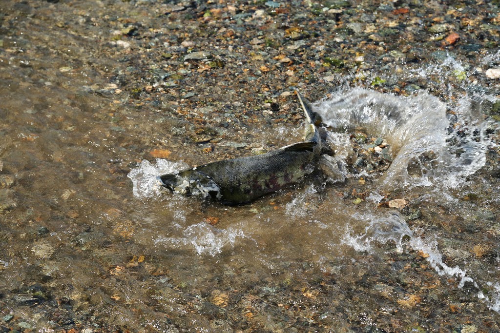 |
| Salmon in Salmon Creek |
There were and there were also thousands of salmon trying to get back into the hatchery where they were born to breed before dying. Whilst we watched the spectacle in front of us, one local reached down and picked a salmon up by the tail before letting it go.
Numerous salmon were either dead or dying after laying their eggs and so the eagles and other birds come to this creek to feed on it all.
It was a good learning experience in terms of how the bald eagles react to people, how close you could get before they flew off and how they interacted with each other. Am still hoping during this trip to get a photo of one swooping down to catch a fish with its talons but it wouldn’t happen here, too many fish for them to simply drag out of the water. There was one juvenile eagle who whilst the tide was rapidly coming in around him, allowed me to get fairly close before it inevitably departed.
After driving to the end of every road leading to nowhere out of Juneau, it was again time to board yet another and different ferry to head further down the pan handle section of coast of Alaska.
If you want a look at more photos… there are 2 links below:
CLICK HERE for more photos - Yakutat & Juneau 2014
2014 - Hubbard Glacier Calving

 Travelling time was a little under an hour and as we got closer to the now familiar blue white face of a glacier, the clouds started lifting almost as if scripted and out came the sun. There was quite a bit of sea ice to manoeuvre through, Mark was very careful to avoid them, but even the smaller chunks did make a large bang when they hit the metal hull. We detoured briefly towards the shore to have a closer look at a large colony of nesting birds with many proud parents showing off their chicks.


