We do not often venture back to places already visited, but in 2022 we returned to Norway and why you might be asking… perhaps a little more on that later.
We had planned to split our time in London with an off shoot trip to Norway and this was a ‘planes, trains and automobiles’ trip with our first flight taking us from London to Oslo where we sat waiting, wondering whether our bags would arrive on the carousel.
Using the ‘Find My’ app we could see the AirTags in each of our bags had arrived at Oslo Airport and were sitting out on the tarmac. Just had to be patient and after 40+ mins, they turned up.
 |
Route from Oslo to Bodø with
lines for rail journey and road travels |
Oslo is a city of ~1M people, a nice size and the locals don’t seem to get overly lost in too much fashion, especially with temperatures hovering around 5C. With only 1 night in Oslo, we were out wandering throughout the city straight after breakfast.
 |
| Downtown Oslo |
Its a nice city to meander through and wasn’t very busy, so could casually walk past the cathedral, National Theatre, the Royal Palace, climb to the fort and admire the Nobel Peace building, sitting sedately near the ocean, all under clear skies, wispy cloud and some direct sunshine.
 |
| Walking down towards the Palace |
 |
Coloured flowers are used for decoration
throughout the city in large pots |
 |
| The Palace |
 |
| Oslo harbour |
 |
| Nobel Peace Prize building in Oslo |
Our goal for Norway however was much further north, so we boarded our first train to Trondheim, a trip of ~6hrs with numerous stops at small towns and villages on the way.
There are some very large lakes in Norway as we seemed to glide past one in particular for a long time, the farms adding to the scenery.
 |
| One of many very large lakes near the railway |
 |
| Yet another lake and farmhouses |
Our arrival into Trondheim at 9pm was miserable in terms of thick cloud, rain and around 4C to really make us feel welcome, and next morning it seemed like the rain had only got heavier.
Trondheim was a 2 night stop as it seemed there was a bit to see, but would need to start in the rain with not a hint of sun to be seen. We ventured out anyway and thankfully the forecast was accurate, the rain slowly easing throughout the morning.
 |
| Wandering through Trondheim in the rain |
 |
| The decorative flowers again |
Trondheim is a good walking city of ~200k people located next to a harbour, with some islands visible in the distance and a lot of very quaint buildings to admire. We were taken by the steep roofs and hanging gutters, designed we believe to enable the snow in winter to slide off the roofs without taking the gutters with it.
 |
| Local house with 'hanging' gutters |
 |
| Modern apartments next to the river |
Yet another very ornate cathedral we did not venture into, whilst walking around the town, finding an old bridge over the river with historical colourful warehouses on either side of its banks, making their way back towards the port and ocean.
 |
| 150 year old Trondheim Nidaros Cathedral |
 |
| Old colourful warehouse either side of the Nidelva River, Trondheim |
There was a road leading up a hill towards Kristiansten Fortress, a fort built between 1681-1685 by the Norwegians to defend themselves against Sweden and it worked when the Swedes attacked again in 1718 and laid siege to the city.
At the base of the hill is a unique mechanism called a ‘trampe lift’ constructed to help people riding pushbikes reach the top of the hill more easily and is a free service. Whilst sitting astride a pushbike, riders push a start button and wait for a pushing plate to come up behind one foot to push the rider up the hill. Couldn’t see it work because it was turned off for winter.
 |
| Trampe Lift instructions |
CLICK HERE for Trampe Lift Trondheim
[Credit for this video is produced by Copperhouse Films]
The port area near the rail station has some interesting architecture, then found a drone boat being tested for sea rescues either manned or unmanned and for military purposes.
 |
| Some fabulous architecture near the port are |
 |
| A drone boat |
It was an early and chilly start to catch our next train from Trondheim further north to a small town called Bodø, located next to the ocean and what a very good journey it was, even if around 10 hrs long.
Again there were lots of stops at more interesting and small villages, including the old ornate rail stations we stopped at. As we progressed, we followed next to fast flowing rivers, could spy numerous waterfalls between the forests of pine trees and slowly climbed higher, snow capped mountains more frequently capturing our attention.
 |
| Small old railway station |
 |
| Waterfall poking its presence through the forest as we passed |
 |
| The railway followed multiple rivers as we progressed |
 |
| The further north we progressed the more barren the landscape |
As we neared Bodø we climbed higher in altitude and the trees began reducing in both size and quantity, until eventually a sign inside the carriage flashed we were passing into the Arctic Circle, herds of wild reindeer next to the track seemingly there to welcome us. |
| Crossing into the Arctic Circle |
 |
| Reindeer next to the railway |
A man had joined our near empty carriage about 2 hours from Bodø and he was as interested in taking photos from the train including through the glass rear door as we were.
 |
| Nearing Bodø even more waterfalls |
Eventually we got talking and discovered he now lived in Bodø, had originated from Kenya and would be soon visiting his parents who lived in Adelaide, Australia.
Had a great 2-way discussion about all sorts of topics, as well as being provided with some tips about the Lofoten Islands and Bodø.
It had been a great train trip but our arrival into Bodø was as expected… cold!
With only one full day in Bodø, we had heard about a particular spectacle 30 kms out of the city we were keen to see, and during our train trip had been researching how to see it. The best way was to rent a car because taxis were stupidly expensive.
 |
| Municipal building in Bodø |
 |
| Modern apartments in suburbs of Bodø |
As most things are comparatively expensive in Norway, including rental cars, we luckily found ‘Rent-A-Wreck’ with a very small, bright green and manual car to zip… no, glide… no, chug around in. Changing gears manually with my right hand on the ‘wrong’ side of the road was also an additional experience. |
| Our little green 'Rent-A-Wreck' was a tad squishy |
Before reaching the spectacle we visited the beach and coast on the opposite side of the town because what we mainly wanted to see was tide time dependant, but we did reach Saltstraumen Maelstrom in time.
 |
| Coastal views north of Bodø |
 |
| Beautiful but remote location to live or stay |
 |
Numerous homes have grass planted on
the roof for natural insulation |
To see the maelstrom we walked to the middle of a long curved bridge to observe this spectacular but natural occurrence which occurs four times every 24 hours. The bridge straddles the 3km-long, 150m-wide Saltstraumen Strait and the worlds most powerful tides cause one fjord to drain into another, creating the equivalent of a maelstrom or whirlpools below and near the bridge.
 |
To watch the maelstrom we needed to walk to the
middle of the bridge and it was windy & cold |
Standing on top of a wind swept bridge in 5C temperature was certainly cold but looking down at the churning, constantly changing, whirlpool riddled 20-knot current created chaos shifting over 400 million cubic metres of water one way, made us ignore being cold.
 |
| A small section of the current & whirlpools |
They run jet boat tours to and through the maelstrom and we were lucky enough to watch one of these tour boats doing exactly that. You can even snorkel amongst it apparently! |
| Luckily for us a jetboat came by to 'play' in the current |
CLICK HERE to watch video of the Salstraumen Maelstrom
Our flight from Bodø to Svolvær, the capital of the Lofoten Islands was a mere 25 minutes and the start of the ~200 km long and remote island chain of very rugged beauty, 150+ kms north of the Arctic Circle.
 |
| Photo of massive poster in Svolvær Airport showing runway |
 |
| Trying to put into perspective where the Lofotens are located |
 |
| Route map showing flight to Svolvær and where we ventured over 5 days |
We collected the hire car and found our accomodation to commence 5 days exploring this very, very beautiful part of the world. We were here in October for a few reasons, the 2 main ones being it was where I wanted to celebrate one of my larger birthdays and also to try and see the Aurora Borealis, the latter being very improbable due to seasonal weather conditions.
 |
| Out the front of our accomodation in Svolvær |
We had briefly visited the Lofotens in 2009 so it was not new to us, but had left a lasting impression on us, especially when you can drive the entire length of the chain of 7 main islands, the road crossing over bridges or through tunnels. |
| There are many bridges like this the length of the island chain |
To really experience the Lofotens you need to explore away from the single main road down the island chains’ backbone, and this is an experience with most of the roads being quite narrow, with few road indicators, no centre line markings and no verges to escape to.
There are also many single lane sections with passing ‘bulges’ to allow negotiations with other cars, trucks or buses wanting to pass in the opposite direction.
 |
To reach many small villages means driving single car width
roads including through the tunnels through the mountains |
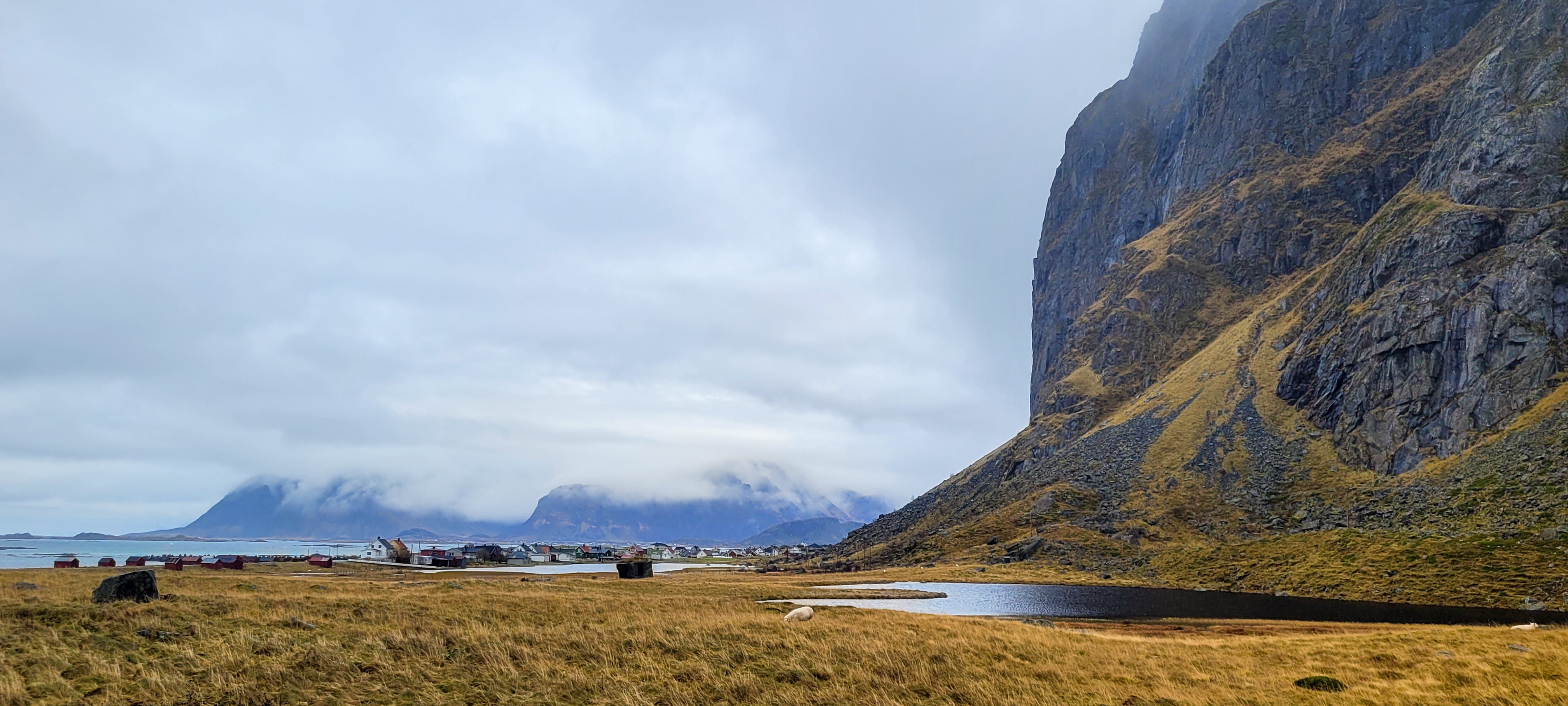
Lofotens are rugged with very large jagged mountains to be seen and negotiated everywhere. These mountains are also located very close to the ocean which provides a constant visual presence of spectacular landscapes and scenery, including small villages nestled between the base of mountains and the ocean.
 |
| Wild ocean seas, rugged mountains and a small village |
 |
| There is a constant supply of very stunning views on the Lofotens |
 |
| Quite remote church we found |
 |
| Drive round yet another bend and you might find this |
The mountains also provide some great but long walks with people climbing to the top of some to get spectacular views of the coastline. With the weather being experienced we weren’t tempted to do any of these |
The red huts are called rorbuers and are fishing huts but
many are now rented to tourists |
The Lofotens are renowned for cod fishing with the season kicking off in January and the racks they air dry the cod on can be seen everywhere along with dried cod being used for decorations sometimes.
 |
| Cod are dried in the open by hanging them on these racks |
 |
| Dried cod being sold to eat... somehow |
 |
| Dried cod light fittings |
One particular mountain next to Svolvær also provides and exciting venue for thrill seekers. It is called Svolvaergeita or ‘The Goat’ because of its shape and is 150 metres high which doesn’t sound very high… but wait!
 |
Pay attention to the multi pronged peak
to the left of this photo |
There are adventurous people who somehow climb ‘The Goat’ and then jump from one horn to the other… don’t believe us, then watch this!
 |
Yes they jump from one horn to another which we
observed in 2009 [credit to photo via Google] |
CLICK HERE to watch video of Svolvaergeita
[Credit for video to Mountianreporters.com on YouTube]
With seven main islands, there are also hundreds if not thousands of smaller islands everywhere adding to the amazing nature of this place and in the village of Henningsvær, there is even an island which is home to a soccer field, potentially the only one of its type in the world.
 |
| The soccer field on its own island in Henningsvær village |
There is just so much to see and explore so will simply use possibly too many photos following to share some of this with you
October is meant to be one of the better Aurora viewing months but also happens to be on average, the Lofotens wettest month. During our time in the Lofotens, a weather system stuck off the coast produ
cing regular and constant rain and almost continual cover of cloud day and night.
We were lucky to get small breaks in the rain during the day to explore and take photos but at night with all the cloud, let alone rain and despite knowing the Aurora was active above us, we never got the opportunity to see it, despite venturing out later at night and giving it a go.
 |
| Is there a hint of green... there was certainly cloud & rain |
On our way to the last small town of Å on this island chain, we had to cross some beautiful and at times curved bridges and tunnels. We would frequently leave the main road, heading down very narrow roads winding amongst the mountains and through some remarkable tunnels serving the small villages, one even to their surf beach complete with surf shops and yes, there were 2 people out surfing.
 |
| The main Lofoten surf beach and there were 2 people trying to catch waves |
We liked the Norwegian people we interacted with because they are very down to earth, pragmatic and seem to enjoy life. They are not stuck with any airs and graces, preferring to dress and behave like many Australians… especially in country towns.
Despite the very inclement weather, almost constant cloudy skies, temperatures 24 hrs a day of around 4C, strong winds, the Lofoten Islands was still stunningly beautiful and it was sad to leave taking our 3 flights to return to London knowing we would not visit Norway again!
CLICK HERE for more Norway photos
CLICK HERE for video of above the Lofotens
CLICK HERE for some Norway 'Bits & Pieces' video
As they say in Norwegian, ‘Takk for besøket, vennligst fortell vennene dine’, it could well be worth a visit, so if so inclined… go well!