This is another trip within Australia primarily focussed on travelling via Queensland (Qld) and the Northern Territory (NT) to reach and explore the Kimberley region of the north west of Western Australia (WA).
This time we were travelling with two good friends Gloria and Pete, enjoying their company until Broome, where we would part ways, they travelling their own route back into Qld and us continuing on within more remote parts of WA as we make our way home.
We departed on the 1st May and would be away for approximately 3 months.
The last time we were in the Kimberley was in 1990 and had been warned many things have likely changed since then.
 |
| Our entire trip route over the 3 months we were away covering ~16,000 kilometres |
This post will cover our ‘To the Kimberley’ travel and as other blogs have previously covered much of our trip through Qld, will keep it simple using a few pictures and video whilst aiming for less words to describe where we went.
 |
| This map shows the main destinations we visited on our way to the Kimberley |
With all the rain having fallen across Qld for many months now, the countryside was very lush with feed for cattle stations and greener than usual which was certainly very different for us. We were also keen to share a few favourite locations with our friends who were embarking on their first long trip with a caravan.
Our first over night stop was at Chinchilla Weir to get us all into the groove via a campfire, some drinks and re-capping on our plan for the next few months.
 |
| Enjoying a campfire out our first stop at Chinchilla |
A few days later we returned to Lara Wetlands near Barcaldine, Qld to enjoy a few days again admiring the location, doing our daily walks around the lake plus soaking in the hot spring. Most of the usual camping areas were closed due to recent rains and minor flooding but it was still very enjoyable.
 |
| Some of the flooding impacting where we could set up |
 |
| The sunsets/sunrises are always great at Lara Wetlands |
 |
| Gloria & Pete loved the hot spring |
Corella Dam located half way between Cloncurry and Mt Isa is massive and very popular with like minded travellers because you simply drive around its perimeter on any of the dirt tracks, pick somewhere to set up and settle in.
Some people literally stay here for months and Gloria & Pete soon understood why. We found a peninsula to camp on for just one night and we were soon a little surrounded.
 |
| We set up right next to the water |
 |
| Small section of the dam... just find a nice place & settle in for awhile |
By now you may be getting a feel that we were moving along reasonably quickly with multiple one night stops and you would be correct. Our travel itinerary timing has been determined by some crucial bookings made once we arrive in the Kimberley, more on those in the next post.
Between us we had planned a few locations where we would stay multiple nights either to re-stock or simply enjoy a special location.
Mt Isa was a ‘restocking’ city, not just for food but in our case to have our 4th covid jab and vote for the coming Federal Election. We had a few minor technical issues to sort out as did the others before venturing further on.
 |
| These pop up in lots of places including toilet bowls |
 |
| No jumbucks at this Camooweal billabong |
 |
| Enjoying the peace and good conversations |
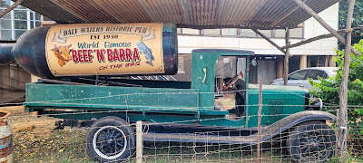
The Northern Territory (NT) is a sparsely populated part of Australia and has the reputation for enjoying a more laid back, irreverent and ‘she’ll be right’ bush style of life and it wasn’t long before we walked into it… welcome to the Daly Waters Hotel!
 |
| One of a few welcome 'signs' to the Daly Waters Hotel |
Located 589 km south-east of Darwin and 916 km north of Alice Springs on the Stuart Highway, this pub was built in 1930, so its a long way from nowhere to go for a drink.
 |
| The owner of the hotel with his friends |
 |
| Very novel men's toilets |
The whole pub and surrounding area is quirky with its signs, toilets, the bar and very obviously a major stopping point for most people travelling up the Stuart Highway. Our timing was good because it was the kick off night for their ‘beef & barra’ dinner.
 |
| Enjoying our 'beef & barra' with LOTS of other people |
 |
| They have their own unique philosophy in the NT |
 |
| Original Mataranka pools now more commercial |
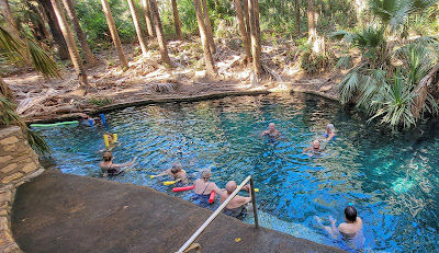
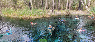
Whilst visiting the original pool, we spent much more time enjoying the nearby but smaller and more natural warm waters of Bitter Springs, a short walk from our caravan park. The water was clear and warm with the ability for us to enter at one end of the springs, slowly drift downstream amongst trees before exiting to repeat this relaxing cycle.
 |
| More natural and rustic Bitter Springs pool |
It was a good opportunity to take video of the experience which can be watched clicking on the link below.
CLICK HERE to watch video of Bitter Springs
Kakadu is well known and famous worldwide so naturally we headed that way, staying for a few days in Jabiru, using this as a base to visit many of Kakadu’s attractions, not all of which had reopened after the recent wet season.
To see things in Kakadu involves quite a lot of driving within this huge National Park, so we focussed on a few destinations kicking off with a visit to Cahill Crossing, the natural and tidal boundary between Kakadu and indigenous owned Arnhem Land. There are limited times to cross due to large tidal movements and the risks of being washed off the causeway.
 |
| Fishing for barra and needs to be crossed at low tide to enter Arneham Land |
At high tide, it is also a popular place for fishermen trying to catch the elusive barramundi whilst the abundant crocodiles wait patiently to catch both fish and people.
Kakadu is famous for crocodiles of which there are plenty, along with lots of other wildlife as we observed during our Yellow Waters sunrise cruise.
 |
| Patiently waiting for something to make a mistake |
CLICK HERE to view more Yellow Waters wildlife photos
CLICK HERE to watch video of Kakadu
Indigenous history and culture are a major part of what Kakadu is all about and one of the best ways to experience this was with a visit to Ubirr Rock to admire ancient and very detailed rock art galleries before climbing up the rock to watch the sun setting over the vast wetlands spreading out in front of us.
 |
| Small example of the Ubirr Rock indigenous art |
 |
| Beautiful view during sunset from Ubirr Rock |
 |
| Another wonderful experience in Kakadu |
After reaching the Stuart Highway we headed into Litchfield Nat. Park, to camp for a few days and with the goal of swimming at Wangi Falls to cool off from the constant 35+c heat. Small problem being early in the season… the falls were closed due to strong currents as the wet season impacts diminish.
 |
| Plenty of water flowing at Wangi Falls but too much for swimming |
There were alternatives however in the form of Florence Falls, reached by climbing down 100+ stairs to reach the large pool below the falls where we swam and sat beneath the plummeting water before climbing back up the stairs and visiting Buley Holes.
 |
| Very refreshing, especially when sitting underneath the falling water |
Buley Holes is a series of pools formed in a creek as it flows downhill. Some of the pools are small and shallow, others very large and deep and some small but at the bottom of small waterfalls over rocks.
 |
| Aaaah... lovely! |
We found some holes in a small waterfall where we wallowed for awhile to again get some relief from the constant heat of the NT.
Katherine is the gateway west towards the Kimberley but not before doing a 2hr tour along the waterways of Katherine Gorge learning about the indigenous history and culture of this waterway.
 |
| Impressive sheer walls during Katherine Gorge boat tour |
 |
| One of the boats used during the tour |
We did a 2hr, two gorge tour up and down the gorges, stopping to both look at more rock art high up on the gorge wall and to walk between the gorges to take the next boat.
We were now heading west towards the border with Western Australia (WA) as the number of boab trees increased, the rivers got larger and the scenery changed as escarpment landscapes became more prominent.
 |
| You never know what you will see whilst driving remotely |
 |
| We tried fishing without luck but not bad scenery though |
CLICK HERE to watch video of Litchfield, Katherine Gorge & Timber Creek
In the next post we will be 'In the Kimberley so until then... Go well!