Why...

Two mature aged people who love travelling and learning along the way... Our names are Rob (Robyn) & darian in the 60+ vintage of travellers keen to visit parts of the world which will stretch us mentally, physically and emotionally.

27 August 2023

The Northwest Passage & Greenland 2023

We all have things on ‘bucket lists’ to complete before we move on and we are completing one of ours by taking an expedition trip through part of what is called… ‘The Northwest Passage’  (NWP).

“The what??” we hear you saying!  Well the NWP is a difficult sea route between the Atlantic and Pacific oceans using various potential routes through the Canadian Arctic Archipelago of islands.  Refer Britannica to the map below.

Multiple expeditions have been undertaken to find a viable shipping and therefore possible trading route across the top of Canada, costing hundreds of lives lost but eventually found by Norwegian explorer Roald Amundsen in 1903-1906 in the boat Gjøa.

The actual route Roald took through the NWP by hugging the coast

He was lucky at that time, because after his success, year round sea pack ice blocked future transits during the NWPs brief summer until after 2009 when changes in the climate have sort of allowed more semi regular summer travel through the NWP to occur.  A trip through the NWP can be akin in some ways, to the rounding of Cape Horn in terms of risk, but more on this later.


First stop, via Vancouver, was Calgary in Alberta, Canada to then, according to the original itinerary, join a charter flight the following day to Cambridge Bay at the top of Canada and 220kms south of the Arctic Circle.  Some last minute advice before leaving Australia meant things had to change due to thick and densely packed sea ice still stuck at the entrance into Cambridge Bay.


Found a very nice park in Calgary

So it was off to Resolute Bay, located on Cornwallis Island instead, which was a lot cooler on arrival because its over 700kms further north than Cambridge Bay and inside the Arctic Circle.


The actual route map will provide a sense of where we flew to at the top of Canada and where our actual journey took us.

Little dot bottom left is Calgary, then our refuel in Yellowknife
before landing in cold & windy Resolute
In Calgary during our ‘check in’ briefing, we also learned there would be 89 other passengers instead of a fully loaded ship of 130, which we thought would be good and there would be two small charter jets taking us to Resolute, each capable of carrying 80 passengers.
Boarding the charter flight in Calgary to Resolute

Due to the additional distance to Resolute, we made a refuelling stop at Yellowknife in the Northwest Territories of Canada and home to the original ice road used during the winter to supply mines north of Yellowknife.


On arrival into Resolute, we had to put on waterproof pants and coats for zodiacs to ferry everyone out to our expedition ship for the next 15 days, as we traverse somehow from west to east, through approximately 50% of the legendary NWP… hopefully.

Rob putting on life jacket
Part of zodiac 'fleet' ready to take everyone
to the ship... a wet, cold but short journey
Below is a photo of where our original itinerary intended going with the areas covered by circles being possible areas where we would explore, make landings or whatever made sense at the time for the conditions.
Original itinerary, the areas in circles potential exploring areas

Please keep in mind we were aiming to traverse part of a legendary route following an itinerary filled with visiting historical remote locations in areas also reputed for excellent wildlife sightings, including polar bear, walrus, narwhal, beluga whales, seals and so on.


The marketing material was beautifully written and hopes were high by most passengers we quickly learned, most of whom were very big travellers.  We were heading into one of the planets last frontiers.


Our ship the Sylvia Earle, built in 2022 and named after a famous environmental scientist, with its curved forward bow, is very well appointed, consisting of an expedition team of 13 (zodiac drivers, gun handlers, guides etc) and ~77 crew to look after us.

Our ship the Sylvia Earle in the NWP
During our first tour briefing by Sue, a very experienced expedition leader, the planned itinerary would have to change, which is quite typical we were told with these types of Arctic trips, due to the influence of wind, seas and ice.  We were shown the sea ice maps, received daily, and how the ice had been moving and congregating due to wind and big seas pushing it.

During our first night whilst trying to sleep, we kept hearing banging sounds which we learned next day was the ship pushing through sea ice as it picked its way across Lancaster Passage and later in the day, we also experienced watching this from the bow (front) of the ship as it pushed its way through a lot of first year sea ice.  


If the ice had been multi year sea ice, this would not have been possible.  Multi year ice is a different colour and and its longer life as ice means it is significantly harder.

Bow of the ship pushing
through sea ice
View from our balcony as the sea ice gently scrapes past
We did spot one harp seal amongst all the ice
Everyone was reminded by Sue we were on an expedition and needed to adapt and be flexible, demonstrated by out first landing in Maxwell Bay on Devon Island, the largest uninhabited island on earth, at a location the ship had not visited before.

Devon Island is very very barren and has or is going to be used for training astronauts to live on and deal with Mars like conditions.

Starting a trek across the very barren Devon island

The landscape on Devon Island is extremely barren

During our walk around a tundra like surface, we learned about a range of flora, many of these plants looking to us like ground cover, but were in fact trees, some being very old trees with gnarly tree ‘trunks’.  Many plants were nearing the end of their flowering season of a few months, and were exhibiting autumn colours.

Cotton plants in bloom
Very old tree with gnarly trunk

The cotton plants were used by the Inuit for ceremonies or for providing heat and light in earlier days using it as large rolled wicks in a bath of seal or whale oil from blubber.

Inuit expedition member showing us how
they light the cotton tree flowers

With an archeologist as part of the expedition crew, we found a potential Inuit heritage site, not recorded in their database, so its gps position was taken and photographed for submission to the Inuit who are now tracking these locations.


During periods whilst the ship searched for new locations to explore, the expedition crew ran presentations on a wide range of topics, including the history of the search for the NWP, which took 400 years to complete and included Captain Cook on his last fateful voyage.


The weather in terms of very strong winds, combined with ice blocking key locations has caused us to not get very far from Resolute, spending most of our time in either Maxwell Bay or Prince Regent Passage, almost opposite each other on Lancaster Passage, a passage used by most more recent attempts to find the NWP.


As we walked on Devon Island we found more plant species
Walking back towards the zodiacs on Devon Island
Icebergs visiting Devon Island
Wind gust of up to 70 knots (over 120 kph) were being experienced, causing the seas to be very rough, resulting in numerous passengers not making it to breakfast one notable morning.

When we could, we would get off the ship to walk on land which initially was not very often as we needed smooth seas to launch and use the zodiacs, including the expedition crew going ashore to check for polar bears and areas we could safely walk on. If they spotted a polar bear anywhere onshore, there would be no landing.


Each afternoon we all met in the conference room for a summary of the day, go through the predicted ice, wind and sea conditions for the next day and possible plans.  Quite often, the plans could only be finalised in the morning due to the conditions.

Purple denotes very strong winds and that's
where we were... in the long section of purple

Whilst cruising further into the western passage of Maxwell Bay, a polar bear was spotted fast asleep near the shore but still 2kms from us.  The sound of the ship and our general presence, eventually caused the bear to sit up, take a good look at us before trotting away from the coast and out of sight but it was still very exciting for everyone to finally see some wildlife of note.  Much of the wildlife is very wary of humans because the Inuit hunt them.


The polar bear woke up... sat up and then took off

We also visited our first Inuit community of Arctic Bay, which doesn't normally receive ships and were given a cultural display of Inuit dancing where they mimic to movement of various animals eg. polar bear, muskox etc.  Even one of the Royal Mounted Canadian Police based here was excited to see us and chat about anything we wanted.

The small community of Arctic Bay
How we came ashore at Arctic Bay

Chatting with the Royal Mounted Canadian Police
One of the community competes in the Inuit Games and demonstrated the high kick involving a seal skin target held by string which is progressively raised until he could no longer kick it with one foot.
Local sharing an Inuit dance with us
A doyen of the community also joined us, a lady who still makes all her own traditional clothes and sells them to make money for the local school.  The very striking part of her endeavours is that she is 103!
The 103 yr old still makes all the clothes seen in this photo and more
Couldn't resist taking this photo of how the Inuit
carry their children (background removed)

The bad weather continued as we zig zagged back and forth across Lancaster Passage searching for quiet places to support zodiac trips to shore or simply cruising around until one ‘zag’ took us to Baffin Island bound for another Inuit community called Pond Inlet.


Lancaster Passage is famous as the starting point for many expeditions searching for a way through the NWP starting with John Cabot in 1497, after multiple failed attempts, including one by James Cook, a major British expedition using 2 ships, lead by James Franklin in 1845 with 120+ people involved, all of whom perished and were last seen in the same Lancaster Passage.


They actually still don’t know what happened to them and why, but they did spend 3+ years stuck in the ice, they found some skeletons, three graves and in only 2014 then 2016, the 2 ships HMS Erebus and HMS Terror found.  We had been experiencing bad weather and ice blockages common in the NWP.


The weather got us again when we arrived at Pond Inlet with 50 knot winds blowing and large waves leaving no choice but to abandon a landing and community visit, instead we turned east bound finally away from Lancaster Passage towards the east coast of Baffin Island.


Since the first crossing in 1903-1906, there have only been 350+ crossings through the full length of the NWP, which includes all cargo ships, occasional submarines, cruises like ours and yachts, which account for the majority of successful crossings.  There are about 7 potential routes depending on draft depth of the vessels and all are subjected to wind, seas and ice.


After rapidly departing Pond Inlet we managed to find a stunning location and sunny skies for awhile, complimented with abundant ice to view and explore using the zodiacs.  It is very strange to slowly cruise amongst sea ice in a small rubber boat!

Slowly cruising towards a glacier
Balancing ice

Very nice experience cruising the front of a glacier and other sea ice
Over the next few days we explored various very long fjords along the east cost of Baffin Island which has an icecap on it like Greenland, each fjord putting on spectacular displays of massive cliffs up to 1.3 kms high, waterfalls, highly patterned rocks and small to large glaciers.
That rock face is 1.3 kms high
The cloud and mist gave it an imposing feel
And ice flows retreating back from the ocean

We anchored in front of one special glacier flowing directly from the icecap and still touching the sea, the only one that still does so on the island, whilst all the other glaciers had already retreated further up the mountains due to warmer average conditions. 

The view we had from our dining room windows... not bad at all

We were able to manage a few landings to simply walk around and in one case, climb a hill on the soft spongy tundra to gain glorious views back along the fjord.

Rob all rigged up and ready to go ashore
View from the top of the hill we climbed
Looking up the river from the bottom of the hill
During one slow cruise towards the end of the fjord, we were lucky enough to spot the backs of some narwhals trying to get away from us.  These were females so they did not have the legendary spike coming out of their heads.
Female narwhals trying to avoid our ship as we followed them
Admiring the patterned rocks on the cliff walls
Working our way from Baffin Island to the east

But the time had come to direct the ship across Baffin Bay and east towards the west coast of Greenland crossing again through some rough seas with 4+ mtr waves and high winds.  Again we were asked to always have one hand on the ship when trying to walk around and numerous sick bags were placed into the handrails throughout the ship for emergencies.


We had reached Greenland, the sun was shining, smooth seas and abundant small icebergs or growlers to keep our Russian Captain amused. Slowly cruising between Disko Island and the mainland, the Captain put on a bridge tour.  What was notable with a ship only 12 months old, how modern and simple the bridge controls looked

What we passed coming into Disko Bay
The Captain running a tour of an impressive bridge on the ship

Time to go ashore for an explore along the beach on the mainland in Disko Bay.  We got our first view of the Greenland icecap and the very green covering across the landscape on Greenland, here at least.

Our first view of the Greenland icecap
All ready for another walk
Part of the Disko Island coast

We signed up for a long walk which first headed down to the beach, finding the remains of a small bowhead whale lying bleached on the shore, behind it stranded icebergs stuck to the ocean floor, also very close to the beach.  Further along the beach was some sort of rock structure and a rock animal trap.

Dead bowhead whale watched over by a stuck iceberg
Rock structure and coastline on Disko Island

The walk continued, including having to cross a creek which one of the passengers fell into, lots of people trying to assist, as a he rolled slightly downstream, drowning and ultimately killing his camera.  Wisely the walk leader found a simpler way back across the creek and decided we needed to climb a hill!!  It was worth is though because of the view.

View from near the top of the hill
Loading onto zodiacs for the trip back to the ship

During the night, we slowly sailed south along the coast before anchoring in a town called Ilulissat, one of Greenlands main tourist ‘hot’ spots, the skies were quite clear, the seas now beautifully calm and going ashore to explore would be very easy.  


This time we stepped off the zodiacs onto a floating structure rather than stepping into the water wearing our waterproof pants and rubber boots.


There were buses waiting for us, soon transporting us to the visitors centre located out of town close to the mouth of a large glacier coming directly from the massive Greenland icecap.


We elected to walk the 1.5kms along a well formed easy path to where the glacier calves off many icebergs a day into the ocean and the view was spectacular.

Walking down to where the icebergs calve into the ocean

So impressive and look closely and you will see boats out with the icebergs

A few small facts about this glacier stunned us.  Due to the increased melting of the icecap and the instability of the ice, this glacier is moving towards the sea at 40 metres PER DAY!  It is also most likely the glacier that gave birth to the iceberg the Titanic struck.  The Inuit locals also told us the individual icebergs are now a lot smaller than in the past and scientists have calculated that this single glacier has raised sea levels by near to 4cms.

Standing near the face of the glacier

The Visitors Centre has been simply but beautifully put together.  You can walk on its roof for views of the city and inside are multiple displays crafted into ice looking structures and multiple video and virtual reality presentations all talking about the life of the ice, research happening on ‘the cap’ and how the Inuit survive and benefit from the ice.  Very enjoyable.

The Visitors Centre overlooking Ilulissat
Walrus tusk
Various ice themed displays in the Visitors Centre

We walked back to town instead of using a shuttle bus, passing large numbers of huskies chained across a large area suffering a little from the 12C heat of the day… it was very hot for them.

Husky camp in town


Various homes and a church in Ilulissat
In the afternoon we boarded a small aluminium boat directly from the ship for a 3hr tour around in and amongst the very large numbers of massive icebergs commencing their journey out to sea and their final grave.

Wow!  This was quite the experience and we had placed ourselves outside at the front of the boat, which was great for photography BUT we soon learned with so much ice all around us, it was like sailing around in a huge freezer… we soon got cold, really cold, especially our hands which held metal cameras.


No other words need to be used… just stunning!


That night we experienced our first sunset for the trip as we had been experiencing 24 hour daylight, despite lots of cloud since departing Resolute, and the following morning we were anchored off the small town of Sisimiut, where we were soon on a short bus tour around town before walking as we pleased through the town visiting museums and famous old churches.

View from lookout to part of Sisimiut
The relationship with the sea is always present
Carving of whales on town's rock face
Famous blue church of Sisimiut
Museum display of old hut

We were now on the home strait south towards yet another very long Fjord taking us to our final anchoring point near the very small town of Kangerlussauq, famous currently for 2 things. 


With these sorts of trips you meet some wonderful other travellers to share the experience and also share their learnings from other trips they have taken.  We met some wonderful people, especially the ones we enjoyed our final dinner with on the ship.

Sue, Colin, Bev and David were great to travel with through the NWP

It is the only location on Greenland where you can drive to the icecap and it has the only runway capable of handling large planes because the runway was built by the USA Airforce during the cold war.

Last time off the zodiacs onto a floating dock

We farewelled the ships crew who had been brilliant, and after landing ashore, found our way to tundra buggies for a town tour before enjoying a BBQ of muskox meat, lamb and beef.


Part of the town tour included driving to the top of a hill for a view, but our driver pointed out this strange looking device sitting atop the hill.  “Can anyone guess what it is?” he asked, with answers like measuring the temperature and weather conditions being most common.

The device outside Kangerlussauq measuring Greenland rising

“No” he said, “it is used to measure how much Greenland is rising as the icecap melts”, “it is rising about 1.5-2cms per year” he added.  Jumping ahead a little, whilst sitting at the airport waiting to leave Kangerlussauq, i was sitting across from 2 geologists from Australia looking for ‘mineral stuff’ on Greenland.  


They said, “yes Greenland is rising it is true and its called ‘Isostatic Adjustment’ “ and added, “ but other countries as a result of the melt from the last ice age 12,000 years ago are rising”.  They advised New York and Norfolk, UK are sinking for example all due to the pliable and putty like nature of the earth’s hot mantle.


“This impacts on sea level measurements but is dealt with using NASAs Jason-3 satellites amongst other tools” they said.


We did in fact drive up near to the Greenland Icecap where yet another glacier was sending large volumes of melt water to the sea.  Quite a sight considering at its highest, this ice is up to 3kms thick.

Our 'tundra buggy' heading towards the Greenland icecap in the distance
Water flowing off the icecap
Closer view of the edge of the icecap
Closer view of the icecap
On our way to and from the icecap… at long last, some more wild life in the form of a single large male caribou and then a male muskox feeding up in readiness for the breeding season, apparently.
Nice big male caribou
Male muskox getting ready for the breeding season

All the passengers except ourselves departed Kangerlussauq on a charter flight bound for Toronto from where they would scatter across the globe, whilst we stayed for one night before a flight heading east next day at midday.


Before departing, early next chilly morning, we went for a walk away from this little town of 500 hardy people to a nearby river flowing into the fjord we arrived into by our ship, to witness the roaring flow of water coming off the ice.  It was quite a sight and in more recent times has generated flooding.


Ice melt water rushing to the fjord and out to sea

Our entire Northwest Passage started off with high expectations around viewing wildlife and historic locations but had become in its own small way a repeat of what many others who venture into the arctic wilds of this area, a contest with wind, seas and ice.  We however did it in comfort with 3 meals a day.

A more detailed of where our Northwest Passage journey took us
So where to next?

We settled into our seats on Air Greenland and headed east out and across the massive icecap to more interesting times but not quite the same as those we had just experienced.

Our plane taking us away from Greenland
Flying over the massive icecap heading east


CLICK HERE for more photos of NWP & Greenland


CLICK HERE for video Northwest Passage to western Greenland


So until the next post…. adieu and go well!


9 November 2022

England 2022

So it’s been nearly 3 years since last visiting England, thanks to good old covid, to see our son, daughter-in-law and 3 grandkids living in London, so time to take the plunge, don our masks and take that long flight.

We learned quickly we were no longer ‘match fit’ for international travel with many little planning items we almost forgot to check but not including double checking any covid related actions required when transiting or entering other countries.


For unknown reasons, we were also a little anxious!


Thanks to a tip from a friend, this time we carried extra carry on items in case our main bags went missing during the flights as airlines and airports ramp up, find then train new staff to meet growing demand.  Thankfully our checked bags did arrive into Heathrow but we did have Apple AirTags in them just in case.

You know your'e in London when sitting back on the Tube

Our time in England consists of two parts, family time in London and personal tourist time.


The family came first and after the 3 year hiatus when unable to attend in person, our son and daughter-in-laws respective 40th birthdays, our granddaughter had doubled in age.  Last time we saw the twin boys they were just trying to stand and now they were running, climbing and talking… a lot!

It was simply great to be able to visit our family in the UK again
Jarad & Rach love watching live NFL (gridiron) and there was a match happening within days of our arrival between the Vikings & Saints at Tottenham Hotspurs Stadium.   Jarad and self joined 2 others to watch the game with almost 61,000 other very noisy, lively spectators.


For half the game had no real idea what was going on but with the help of the others, started to understand it more.  A few beers may have helped and at the end and with only 2 secs on the clock, the Saints had a chance to level the scores to force extra time but fell just short.


Thoroughly enjoyed the whole ‘event’ because that’s what it was, an entertainment spectacle with things happening all the time to keep everyone having non stop enjoyment.

NFL at Tottenham Hotspurs stadium

We had decided to have 2 tourist destinations within England, the first one involving 5 full days in the Cotswolds about 2 hrs west of London staying at a delightful village called Burton-on-the-Water, yes… interesting name but there are so many more quaint names.

Generally where the Cotswolds are located
Each of the many small villages and towns we visited seemed to have a specific ‘speciality’, whether is was a physical site to admire, its history or both and they were all fascinating using Rob’s well designed full daily itinerary for each day.

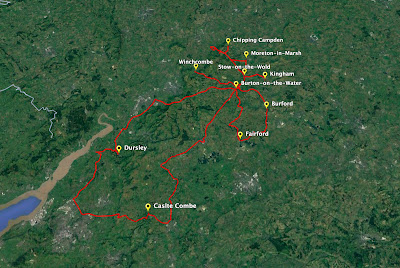
General driving route within the Cotswolds but not all villages shown

In 2007 we dipped our toes into the Cotswolds located about 100 kms NW of London, and its beauty motivated us to return and do a more detailed tour through this part of England.

The beautiful village of Castle Combe
once the location of a Roman Fort

Our base was a lovely Airbnb not too far from the River Windrush running through its centre earning this village the nickname of ‘Venice of the Cotswolds’.    The river can be crossed using 5 stone arched bridges built between 1654 to 1953

One of the old stone bridges in Burton-on-the-Water

Over the next 5 days we visited a variety of towns and villages using a multiplicity of road styles ranging from freeways, normal single lane roads and then laneways which were the most interesting and exciting.


Laneways keep you on your toes because they are typically single lane for all traffic to use and either high hedging or dense tree line close to the side of the lanes.  All this simply means that every time we came to a blind corner screened by ‘stuff’, we had to be very careful due to potential oncoming traffic.


We were greeted by not just cars but delivery vans, trucks and large farm tractors typically towing trailers, all of which had to be negotiated with. At times there were areas off the side to the ‘roads’ we could use for passing, but often it was simply get as for to the side as possible and slowly squeeze by.  Fun!

One of the larger roads engulfed by foliage

Each town or village we visited in the Cotswolds, apart from typically interesting names, had something sort of unique about or in them they were known for, for example:

  • Lower Slaughter - working waterwheel
  • Upper Slaughter - town square which is actually a triangle and a ford
  • Chipping Campden - thatched roofs and Broadway Tower Folly
  • Stow-on-the-Wold - oldest operating inn in England circa 947 AD and an ancient stock
  • Bibury - 17th century Arlington Row of whole weavers cottages
  • All Alone - its all alone
  • Fairford - church from 1490’s with oldest set of medieval stained-glass windows, it took 15-20 yrs to install them
  • Burford - church circa 1170 with great oak roof
  • Winchcombe - castle nearby and row of Almnhouses
  • Tetbury - 15th & 16th century small buildings
  • Castle Combe - started as a Roman hill fort and now with beautiful houses

Hopefully from some of the photos you get a sense of how beautiful and interesting these locations were throughout the Cotswolds.

The onset of autumn was bringing a lovely change of colour
Lower Slaughters working waterwheel
The Broadway Tower folly by design and nature
Porch House... the oldest working Inn in England, circa 947 AD
Very low ceilings in the inn
Arlington Row of weavers cottages in Bibury
Burford church's beautiful oak timber ceiling
Ancient stocks used for public punishment in town square
Amusing village safety sign

Back in London it was time to ‘child mind’ 3 active grandkids whilst the parents had their turn to go to a NFL game, again at Tottenham.  It was recommended to visit Syon Park with 56.6 hectares, the current home of the Duke of Northumberland and a location where Princess Victoria spent considerable time in preparation to becoming Queen.

Duke of Northumberland's home in Syon Park, London
We manhandled 3 lively grandkids and the boys little balance bikes onto the double decker bus and off we went!


The park had lovely paths to follow and explore, especially the ones between a canopy of trees which the twins loved to run through constantly.  Also scattered throughout the park were large  timber steps grouped together they also liked to clamber over.

The Great Conservatory in Syon Park

There were large ponds to search for turtles and admire either the Egyptian geese or swans and in the very ornate Great Conservatory was a fountain housing curious goldfish trying to work out what the little faces were peering down at them.

Be afraid be very afraid goldfish

By the end of the day and all the kids sleeping soundly in bed, Rob and I collapsed… a little exhausted.


We interspersed our time in England with a side trip to Norway which is covered in another post, but on returning, we visited more normal tourist locations.


The Tower Of London and surrounds - home to an the Ancient Palace, the Crown Jewels, Kings armoury and Bloody Tower, our granddaughters favourite and where they carried out torture.

Inside the grounds of the Tower of London

Yeoman Warders or Beefeater @ Tower of London
Our granddaughter was quite taken
by Henry VIII's armour
Thanks to Google, example of the jewels stored in the
Tower of London - photos are forbidden - they were spectacular!
Walking over the nearby Tower Bridge was a treat with the Thames River wriggling like a snake below it.

Tower Bridge as viewed from the Tower of London precinct
Walking across Tower Bridge

The Natural History Museum - famous for all its displays of the natural world but unfortunately packed with school kids on holidays.

One of a few dinosaur exhibits in the museum
Mammoth skeleton

We did venture further afield including seeing a good friend for a delightful lunch in Ealing and visiting the famous Kew Gardens before taking a train and staying for 3 nights in York.

Where York is located in the UK
Where we walked within York over 3 days

What an interesting, enjoyable and fascinating city York is and such a great walking city.  Little bit of history time with York starting in 71 AD when the Romans established a fort there.  


Roman occupation ended in 400 AD and during that time, Emperor Constantius I died during his stay in York, and his son Constantine the Great was proclaimed Emperor by the troops based in the fortress. Constantinople which later became Istanbul was named after Constantine.

Part of the Roman baths used by soldiers used over 1,600 years ago

There is a massive amount of history throughout York, just have to find it

Just to add to York’s character, it is touted as potentially the most haunted city in the world with 140 ghosts and over 500 recorded hauntings and even has a single ghost shop with long queues outside it whenever its open.

Queue of people waiting to visit the
ghost shop in the Shambles, York
Some shops have interesting names even if they can;t have a name

So during the 3 days we wandered all over the city day and night and kicked off at The Minister, York’s massive church in which we did a free tour run by a 80+ year old very humorous lady.  We’re not all that into churches but this one was fascinating.

Very small section of the Minster
seen from outside
Just on section of the inside of the Minister... it is huge

The Minster started life around 627 AD and grew from there and there were so many historical highlights we learnt about apart from the huge stained glass windows and massive structures.

One of the old huge stained glass
windows cost over $12M to repair
The Minster organ has 5,400 pipes!

There are just so many old buildings and wonky ones to enjoy as we found little lanes and roadways to admire and enjoy.  Back to the ghost reputation of York, there was a ghost sculpture display scattered throughout multiple parks and gardens through the city.

One of the numerous 'ghost' sculptures
on display throughout York

York is also a walled city which we walked providing yet another different perspective of the city’s internals and was yet again another enjoyable experience.

There were many great views whilst walking the wall around York,
with the Minster dominating the skyline frequently

To finish off our time in York, we visited their famous National Train Museum and spent a few hours viewing some very famous trains like the 1829 Stephenson’s Rocket, the world’s first early steam train, the Mallard which still holds the world steam train record from 1938 at 203 kph.

You are looking at a piece of history which helped
industrialise the world - Stephenson's Rocket
The Mallard - worlds fastest steam train
There were also some of the Royal carriages built for various Kings and Queens and it was interesting to observe how the early carriages were very ornate and luxurious until Queen Elizabeth’s which was far less so.

Just one of the Royal carriages on display

We had a wonderful and very nice time with our family and friends in England, along with our side tours and after around 6 weeks, boarded good old Qantas for that very long flight home with many lovely memories to keep us company before the jet-lag welcomed us again.

The lively and fun grandkids

What this trip did do was get us back into the international travel saddle again so our planning is well and truly underway for 2023 and beyond.


CLICK HERE for more pics of UK 2022


So keep an eye open for the Norway post and until then…. adieu and go well!