Our flight from Arequipa, was now bound for an area of the world we had wanted to witness and experience for over 40 years, and this destination is one of the worlds great wonders located high in the Andes.
It was our time to visit Machu Picchu!
From the route map below, you can see our journey, not only to Cusco but from there progressively to Lake Titicaca and a new border to cross.
 |
| Our Part 2. journey through Peru |
Whilst flying at 10,000m over the Andes, once again, Sabancaya volcano, the one we saw erupting whilst visiting Colca Canyon, again made its presence felt.
 |
| The dark cloud from the erupting Sabancaya volcano |
Our flight landed in the city of Cusco at an altitude of ~3,400m , regarded as the originating location of the legendary Inca empire, and after settling into our hotel, we very quickly saw first hand some of the Inca’s famed building skills with huge stones.
 |
| The city of Cusco - population ~435,000 |
They really do all fit very closely together; so close you really can’t push a sheet of paper between them.
 |
| The famous 12 face stone in Cusco crafted by the Incas |
 |
| One of many many walls/foundations built by Incas in Cusco |
During our travels within South America thus far, we had already visited Inca ruins in Ecuador posted earlier, but now we were in the heart of Inca territory and where the Spanish conquistadors ended their magnificent reign.
 |
| An indigenous local in Cusco |
All through Cusco we could see the amazing construction skills of the Inca’s but outside the centre of Cusco, we also visited the historical fortress of Sacsayhuaman, built from 1438, the largest structure ever built by the Inca’s.
The fortress is massive with walls almost 400m long and up to 6m high and including some stones weighing between 128- 200 tonnes, and all finely cut to fit tightly together. At one stage, there were also towers they had built within this complex.
 |
| Massive walls of the Sacsayhuaman fortress |
Standing in front of what remains of this fortress, it was mind boggling to contemplate how the Inca’s achieved all this.
 |
| Such huge stones that all fit so closely with each other |
We stayed a few days exploring Cusco, a very delightful but tourist laden city, with its narrow streets and lanes and an abundance of very nice restaurants to enjoy, including one where we had very tasty guinea pig.
 |
| Before |
 |
| After and yes... tasty! |
Leaving Cusco we commenced what would be an Inca intense learning curve, first by following the Urubamba River into what is called the Sacred Valley. This river was at the heart of Incan food production and included the Incas’ skill for building large and very strong terraces located around the sides of very steep mountains.
We reached another historical Inca site called Pisac, where… after a climb to 3,800m and much puffing, we really saw the incredible terraces built by the Incas to produce food.
 |
| Terraces and buildings in the mountains at Pisac |
We travelled deeper into the Sacred Valley, this time reaching our next stop of Ollantaytambo, once the royal estate of Emperor Pachacuti, responsible for kick-starting the formation of the Inca Empire.
Well the WOWs simply got bigger at this incredible location of this old town amongst huge mountains with Inca storage houses on one side of and an Inca fortress and a Temple of the Sun high on the other side.
 |
The city of Ollantaytambo with Incan grain storage
buildings on side of far left mountain |
More amazing structures built using large intricately cut stones and with Ollantaytambo being the last point the Spanish got to whilst fighting the Incas.
 |
| Looking up at the ruins of the royal estate with the Temple of the Sun on top |
 |
| So how did the cut and move these huge stones up to here |
 |
| More of the amazing Ollantaytambo structures |
It was from Ollantaytambo where we caught a train, still following the Urubamba River and passing the start of the ‘Inca Trail’ trek to reach another town called Aguas Calientes.
 |
| Rob waiting to catch the train to Aguas Calientas |
 |
| Travelling further into the valley |
 |
| The Sacred Valley and actual start of 'Inca Trail' to Machu Picchu |
This town is the real starting point for most peoples’ access to Machu Picchu. We stood in a queue, waiting to catch a bus up to this fabled location. The bus trip itself is interesting, zigzagging ever upwards on a dirt road, at times too narrow for 2 buses to pass each other.
As we climbed, our excitement grew and we started to catch glimpses of various structures.
Once through the entrance gates, our guide had us climbing up stone steps built by the Incas to reach the site most people initially go to and where you get that famous view and photo of Machu Picchu.
Wow! There is was and looking exactly the way most of us have seen it… unbelievable!
 |
| Machu Picchu... and what a sight it really is? |
With the sun shining and after a few photos, we simply stood there and admired what was before us… just so stunning, again my head spinning wondering how on earth the Incas created this amazing place.
Our guide then started down, around and through what is Machu Picchu, a combination of a religious structure combined with many homes people of the past lived in.
The religious structures all consisted of those finely cut and fitted stones, whilst the living quarters were built in a much cruder style.
 |
| Courtyard in the midst of the structures |
Over the next 2 hours we roamed throughout the entirety of this world wonder, the Sun Temple, the massive courtyards and royal homes, even a royal tomb… surrounded by multiple high mountain peaks towering above us.
 |
| Viscachas rodents in the ruins are members of the Chinchilla family |
 |
| The curved structure is the Temple of the Sun |
 |
| A royal tomb |
We eventually descended back down to town to celebrate being here and after a great sleep, were heading back up to Machu Picchu, this time on our own to explore further.
Part of this time had us following a very narrow trail around the edge of a steep mountain to the Inca Bridge. At times, Rob wasn’t very comfortable with this because of the narrowness of the trail and the sheer drop.
 |
| Rob standing on the trail with its sheer drop |
The path we were on was one of a few the Incas used to reach Machu Picchu and the Inca Bridge was a defensive structure, again somehow built by the Incas to be destroyed so as to stop any attacks. Again, yet another amazing structure.
 |
| The small bridge was built by Incas on the side of a cliff |
 |
| One final admiring look at the marvel... Machu Picchu |
After 2 fabulous visits to this world wonder, it was back on the train to Ollantaytambo where we were picked up and taken to a hacienda in the small town of Urubamba.
Before reaching the hacienda, we stopped to look at the Skylodge, consisting of accommodation capsules perched 400m up on the side of cliff, which you have to climb up to if you’re staying in them.
 |
Look closely and you can see people climbing
on the right hand side about half way up |
 |
| Want to stay anyone! (not our photo) |
On our way back to Cusco we visited the Maras salt mines, in use for almost 500 years, which produces salt from water flowing out from under the mountains.
 |
| 500 year old salt mines the sky |
Next yet another fascinating Inca site, the ‘Moray circuses’ consisting of a large, medium and small concentric spiral Inca terrace structures, all in a perfect circular shape, used by the Incas as a market garden laboratory.
The Incas tested growing various crops due to the progressively different temperatures found down through the spiral structures, terrace by terrace.
 |
| The Moray Circus terraces built again by the Incas |
A little later, we walked through the traditional village of Chinchero, also filled with Inca structures and originally a Royal Inca site and again the location of many terraces.
 |
| Village of Chinchero |
The Spanish destroyed much of this village but again like Cusco where a lot of destruction also occurred at the hands of the Spanish, the strong Inca walls remain and a fascinating old church built atop Inca walls with big mural paintings across the ceiling.
 |
| Chinchero Church |
 |
| The mural (not our photo) |
In Chinchero, we also watched ladies drying potatoes by laying the small ones out on the grass for 2 days in very cold temperatures, even letting them freeze, then squeezing water out of them using their feet before letting them dry further till rock hard. They store these dried potatoes and use them progressively.
 |
| Drying potatoes in Chinchero for long term storage |
Medium size potatoes are used for the next year’s crop as seeds and large potatoes are used within a month of being picked. Peru has 100’s of types of potatoes.
We had progressively increased our knowledge about the Incas and what a culture they were, but it still amazed us how much they had achieved between 1438 and 1532 from their starting location of Cusco before the Spanish decimated them.
At their height, they ruled over 10M people of other indigenous cultures, mainly through conquest; they built masses of roads/trails, massive buildings, created a centralized economy, medicines, accounting systems, aqueducts and huge numbers of terraces.
 |
| Indigenous dancers celebrating in Cusco |
They absorbed and used knowledge of many other indigenous groups in existence for thousands of years before them and their influence stretched from the north of Ecuador to southern Chile… all in only 100 years.
As one of our guides shared with us, “the Incas were the Romans of South America”.
After a few more days enjoying Cusco, we boarded a bus early in the morning for a 10hr trip, with multiple stops along the way, bound for the town of Puno.
 |
| Enjoying the central park in Cusco |
The stops we made consisted of:
· Andahuaylillas– a church known as the Sistine Chapel of South America, very ornate with cedar structures covered in gold leaf and constructed from 1570 by Jesuits.
 |
| Photo sourced from Google |
· Raqchi– with its large, long perimeter wall and structures made with very tall columns, combining Inca built rocks, integrated with local indigenous adobe mud bricks to build the Temple of Wiracoocha. There were also many homes and round grain storage structures.
 |
| Part of Temple of Wiracoocha |
· The town of Sicuani- lunch stop
· La Raye– the highest point in the trip at an altitude of 4,335m where the Andes mountain range divides, with one section going east the other west to ultimately go either side of Lake Titicaca.
 |
| Where the Andes split for awhile |
· Pukara– site of archaeological artefacts going back to 1,800 BC of the indigenous Chipira period.
We finally arrived into Puno located on the shores of Lake Titicaca, the highest navigable lake in the world at 3812m above sea level and also regarded as the original birthplace of the Incas, not where they established their empire. It is also the largest lake in South America.
 |
| The city of Puno on the shores of Lake Titicaca |
Next morning we started a tour of the area and after a 2hr drive off the beaten path from Puno, we reached and walked through a rural Aymara community, with some encounters with the locals.
 |
| Mud bricks still used for construction |
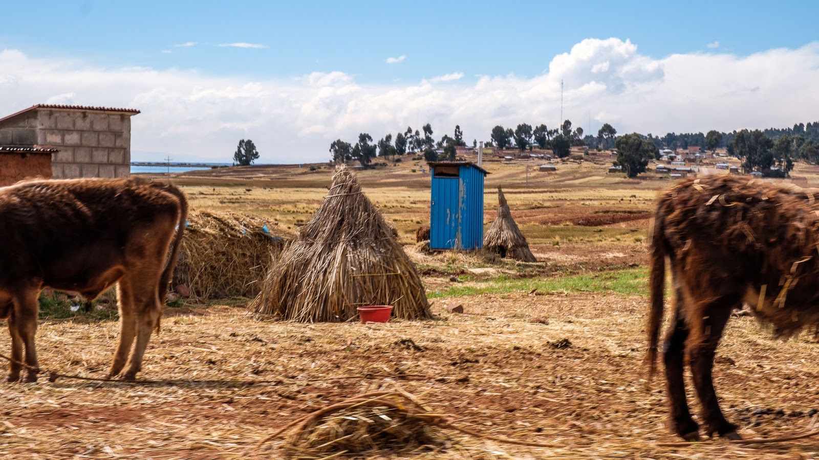
Our guide is from the same indigenous group and they were warm, friendly people who live a very basic life in either mud brick or some clay brick homes, growing small crops, storing hay and proudly now having new outside drop toilets, some with environmental systems.
 |
| The community now have access to external drop toilets or dunnies |
Our guide took us for a 2hr walk up to the top of a hill with great views over both the lake and back to Puno at over 4,000m and we were meant to go to a floating village on Lake Titicaca, BUT a massive and very unseasonal storm arrived making the lake VERY rough to travel on… oh well.
 |
| Climbing to 4,000m for a better view of Lake Titicaca |
 |
| There are a lot of fish farms on Lake Titicaca |
 |
| Lake Titicaca on left, the small lake on the right and the community we visited in the middle |
The following day, it was time to leave Peru and cross into Bolivia, which involved a 2hr drive to the border. As we approached the border, the heavy rain that was falling, progressively turned to sleet and then to flurries of snow, which melted as soon as it hit the ground.
It was cold, very cold as we queued in the rain/snow outside the Peruvian immigration building before then walking through no-mans land until we reached Bolivia’s immigration hut, where again we queued, snow on a small cover outside their office.
 |
| About to cross from Peru into Bolivia in no-mans land |
 |
| Waiting at Bolivia's Immigration building |
Our time in Peru had come to an end, so until we start our new adventures and journey through Bolivia… go well!


No comments:
Post a Comment