Well… what follows are descriptions of the final 3 days of travelling through Bolivia and we hopefully have left the best for last, considering we rate these 3 days amongst the list of main highlights of our entire trip within South America.
During these 3 days we also took the largest number of hand held panorama photos ever taken on any trip anywhere in the world, one for example involving 17 individual photos which were then stitched together.
So apologies for possibly too many larger landscape photos in this post.
So lets try to explain what these 3 days consisted of after leaving Uyuni and heading mainly south towards the border with Chile.
For a start we travelled the entire time in a 4WD with our Bolivian driver Luis, who spoke only a little English. We travelled ~548 kms with roughly 95% of it off road and at altitudes ranging between ~3,600m to 5,000m through the Bolivian Andes mountains.
The map below shows our actual route after leaving Uyuni and wandering into the wilderness.
Day 1. – Salar de Uyuni (Uyuni Salt Flats)
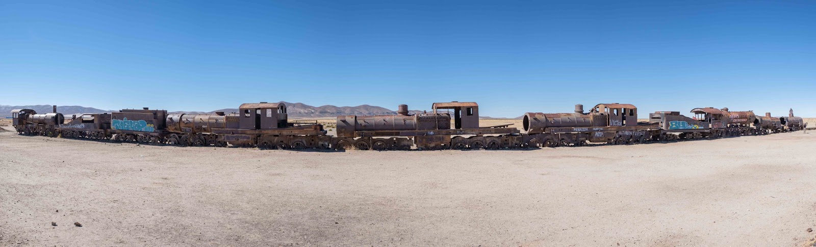
After meeting Luis and loading our gear into the 4WD, first stop on the outskirts of Uyuni was a train graveyard full of rusting steam engines
 |
| Old trains... trains everywhere |
In bygone years, after the railway was built in the late 19thcentury, these trains were used to transport silver nitrate mined in Potosi to the coast, but alas when prices tanked in 1940, everything declined and hence the train graveyard.
Before reaching the salar (salt flat) proper, we made a brief stop at the salt museum, detailing the mining of salt over many years and then reached the edge of the salt flat, where we were stopped by a 4WD that had already got into trouble.
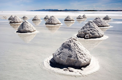 |
| How they still mine salt on the salar (Photo courtesy of Luca Galuzzi) |
 |
| How it ended up there... no idea! |
This salar is the largest on the planet at roughly 10,500 square kilometres in area and used periodically for some of the famous Dakar off-road races. To put this into perspective, the famous Bonnevile Salt Flats are a mere 104 square kilometres.
 |
| Recognition in salt to the Dakar event |
As we started driving out onto its vast expanse, there were small dark shapes on the horizon and the constant visible company of the distant volcano Tunupa.
 |
| The salar is simply massive |
The Uyuni salar is part of the Bolivian Altiplano, or high plateau, formed during a major uplift in the Andes Mountains, hence its vast flatness was formed as a result of some massive prehistoric lakes drying up over 40,000 years ago.
Some of the dark shapes in the distance were other 4WDs also travelling west, or coming towards us, but other dark shapes were either mountains or islands located on the salar itself.
Remember all the snow that had fallen in Potosi? Well it had also fallen for many days longer over the salt flat and had now melted, leaving a lot of water we began driving through and something Luis kept muttering, “not normal, not normal”.
Slowly but surely, as we progressed across the flat, we started driving through water lying on its surface, at first a few puddles but eventually consistently about 6-7cms deep across the entire surface in any direction we looked.
 |
The water on the surface of the salar starting to increase
with Tunupa volcano in the background |
Luis reduced speed considerably to try and reduce the amount of now very salty water being splashed up under the car in an effort to minimise its corrosion effect.
We were a little lucky to be driven by Luis after noticing something on his arm and asking, “tattoo” to which he responded, “me Bolivian navy… Lake Titicaca”, so he was at least used to being on water. It was quite a surreal experience because it felt like we were sailing on a massive lake but in a 4WD.
After a few hours of progress Luis stopped on a small circular ‘island’ of salt about 10m in diameter and 3-4 cms above the water level and exclaimed simply, “lunch”.
With that Luis started setting up a small table with tablecloth, some chairs retrieved from the car’s roof, china plates, cooked lama, chorizo sausage, potatoes, quinoa, avocado, tomato and drinks.
 |
| Luis setting up for lunch on a small salt island on a salt flat... no lake... no salt flat... |
 |
| ...and enjoying it! |
We, in the meantime surveyed the scene around us, the glistening water disappearing into the distance in any direction, Tunupa volcano now reflecting in the mirror effect of the water.
There we sat on our tiny salt island, clear blue sky, an occasional 4WD passing by on the horizon, an eerie silence returning whilst having a lovely lunch. Unbelievable!
 |
| Another car 'sailing' by during lunch |
On our little dry salty island there were holes filled with dark water that seemed to descend into the depths… and they did Luis again told us with, “salt 8 to10m deep, agua 80m below salt”.
We also learned after reaching Chile, salar Uyuni also contains 50-70% of the world’s lithium in the brine water below the salt surface, a massive opportunity for Bolivia if they can both extract and export it.
Lunch completed, on we drove and it was getting warmer in the car and Luis seemingly started nodding off briefly to sleep. I was in the front seat with him but didn’t do anything when it happened because we were going slowly and there was nothing for us to hit anyway! He always woke up and corrected course a little, then started chewing coca leaves to give him extra energy.
We had been heading towards one of those dark shapes on the horizon for hours, Luis telling us, “Isla de Pescado” (Fish Island) which finally we reached and drove round to the back of it… OMG! There were lots of 4WDs parked, a restaurant, shops and toilets.
 |
| Other 4WDs parked at the island in the salar |
There are also a huge number of cactuses covering the island which we learned grow at the rate of about 1cm per annum, which makes some of them higher than 10m, very old indeed.
 |
| Rob standing next to a tall cactus |
This island was originally a reef as could be seen and felt as we climbed the rocks and path to the top of the island to enjoy the stunning views, including other 4WDs driving over the salar and the now larger reflections of Tunupa volcano.
 |
| View from the island, 4WD driving on the salar and Tunupa volcano in the distance |
 |
| It was hard to tire of this view |
Departing the island, we now headed south on our own across salar, infrequent small piles of rocks standing in the water, the only ‘signposts’ to guide us.
 |
| Other tourists enjoying themselves on the watery surface of the salar |
We stopped briefly for Luis to pump up a tyre before continuing, finally reaching the edge of the salar and bouncing onto a rough and often corrugated dirt track.
 |
| Luis pumping up a tyre before we leave the water and salt |
Following the track, and with the sun beginning to set, we skirted the boggy tip of the salar then headed into the wide-open spaces, passing a pre-Incan cemetery, probably of travellers who had got lost eons ago, the darkness also descending on us.
On we drove until in the distance we saw a few lights from the indigenous village of 500 people where we would be staying in overnight. The hotel was comfortable, the locals very friendly, including putting on a very nice dinner. What a truly surreal day 1.
 |
| Tunupa volcano and its reflection... the small black dot in the middle of the photo is a 4WD |
Day 2. - Into The Desert
After leaving the hotel we ventured on, detouring briefly to have a look at a very small ghost village used by the Bolivians to hide in during the last big war with Chile. They lived there for 20 yrs without ever being found and returned eventually to the village we had stayed in the previous night.
 |
| Deserted village which saved hundreds of Bolivians during the war with Chile |
On and on we drove, the expansive vistas constantly beckoning us to take yet another photo, on one occasion finding ourselves standing in a desert with 5-6 snow capped volcanoes breaking the horizon in front of us.
 |
| We drive out across the Chiguana salt flat |
 |
| In the distance stand multiple volcanos |
Whilst crossing the Chiguana salt flat, we came across the Uyuni to Calama (Chile) rail line, so stopped and climbed onto the raised tracks to view the line disappearing off into the distance.
 |
| Railway to seemingly nowhere |
From here Luis changed direction going overland, at times making our own track as we climbed amongst the mountains until we spotted our first sight of the active Ollague volcano, eventually reaching a viewpoint used by everyone.
 |
| Going overland looking for a volcano |
 |
| Ollague volcano smoking in the distance |
Finally reaching our first lake perched amongst even more snow capped and very beautiful peaks, Luis muttered, “lunch here okay”, so we parked next to the lake with other 4WDs and set up all the bits and pieces. Lunch this time had been cooked by Luis’s Mum who lives near the village we stayed in the night before.
 |
| Lunch by the lake |
We were not alone and this doesn’t mean the other tourists of whom there were quite a few, our guests for lunch were many flamingos feeding in or flying around the lake. So you can surely guess by now… LOTS of flamingo photos, many with them complimenting the surrounding landscape.
 |
| Flamingos with their stunning backdrop |
 |
| Graceful flamingo on the wing |
Progressively we moved onto multiple other lakes, each quite different and one also with even more flamingos, a group of them doing the dance they are famous for, so yep… more photos. Until now all the lagoons were fresh water then oddly, we came upon a very picturesque salt-water lagoon.
 |
| Different lake with even more flamingos |
 |
| Group of flamingos start their dance |
 |
| Massive salt lake |
To progress further, we found ourselves driving through an area called Inca Gorge, because of how thousands of large rocks are stacked atop each other to form the gorge wall itself. Within the gorge lives the mountain viscacha, a rodent closely related to chinchilla with a long tail looking a little like a rabbit kangaroo to us.
 |
| Inca Gorge |
 |
| A mountain viscacha sunning itself |
We emerged out of the gorge and started our drive across part of the Siloli Desert where we also came upon an Andean fox gorging itself on something, unbothered by our presence, food being its priority in this tree and grassless environment.
 |
| Andean fox enjoying a feed |
Now at over 4,800m altitude, in the distance we saw, then finally reached our accommodation for the night, the very remote Tayka del Desierto Hotel. During check-in, we were told we had to have showers that night because there would be any hot water next morning or heaters, which also were only used from 5:30-10:00pm each day!
 |
| Lots of open space and no real track on the Siloli desert |
The hotel was full of tourists and the restaurant we all descended on, was actually very well run and provided excellent food, despite its remoteness.
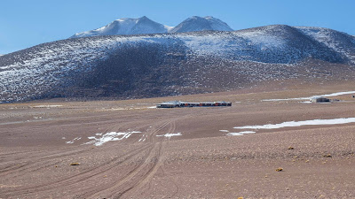 |
| The very remote and high Tayka del Desierto Hotel |
We had experienced another amazing day absorbing non-stop vistas in some incredible countryside
Day 3. – More lakes and desert until Chile
The sun rose on our final day in Bolivia around 6:30am, and at the altitude we were at, it was a bit chilly inside the hotel as we enjoyed breakfast before leaving around 8:00am.
Why is this important… well when we departed and after 1.5hrs of sunshine, the outside temperature had reached -12c, yes minus12c as we drove off back into the Eduardo Avaroa National Park looking for the ‘Stone Tree’ which we found about 1 hr later.
There is a single massive rock, sort of shaped like a tree, standing with other very large rock formations in the middle of no-where, apart from of course, mountains in the distance.
 |
| The 'Stone Tree' |
 |
| More of the stone structures in the Eduardo Avaroa National Park |
These natural structures and surroundings, like much of the last few days, made us feel very insignificant indeed, next another 1 hr drive bouncing over a stoney plain before catching views of Laguna Colorada or ‘Red Lagoon’. Yes it is sort of red caused by red sediments and algae pigmentation in the water.
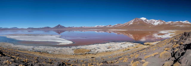 |
| The captivating Laguna Colorada |
Standing overlooking this massive lagoon at 4,800+m was almost unbelievable, with warm thermal water rising at one of the lagoon where more flamingos were gathered, and snow capped mountains at the other end.
 |
| Steam rising from the 'Red Lagoon' and flamingos enjoying the warm water |
We paid to formally enter the National Park at Laguna Colorada and from here, the next section of driving climbed even higher and much of the time was very bumpy with snow and ice all around us.
Almost got bogged in snow and mud in one section as we nudged 5,000m before reaching the geysers, including bubbling mud and steam escaping from various orifices, along with that 'wonderful' smell of sulphur.
 |
| Geysers and hot bubbling mud at nearly 5,000m |
Boliva also has thermal power generators established at this altitude as part of their creation of electricity and did make me wonder why we can’t do the same for base load power… hmmm!
On our way towards the border with Chile we briefly stopped at some thermal hot springs set next to yet another lagoon, tourists enjoying a relaxing bath in them. We didn't stay however because we were on a tight schedule to meet a transfer at the border.
The drive just kept on being stunning as we constantly asked Luis to stop for yet another picture, in fact he got very good at reading the signs when either one of us started fidgeting with our cameras.
 |
| Yet another landscape to photograph as we near the border with Chile |
This part of Bolivia has an abundance of volcanoes, but one called Licancabur was particularly impressive near the border with Chile. As we got closer to it, and after multiple stops to take photos of it, we passed the White Lagoon, given its name because its usually frozen, then soon after, came over a ridge and Licancabur stood there in front of us.
In front of Licancabur keeping it company was Laguna Verde or the Green Lagoon, which itself was surrounded by snow and ice mixed, with brown rocks and soil… yet again, breathtaking!
 |
| Licancabur volcano behind the 'Green 'Lagoon' |
Even getting to the border with Chile was an adventure as we drove around the edge of the Green Lagoon before stopping for our final lunch with Luis, who had got us to the border safely and was good company... job well done.
 |
| Driving around the 'Green Lagoon' to reach the Chilean border |
Finally we reached the Bolivian Immigration control located in a little wind blown, cold ramshackle rock hut, where after stamping our passports and holding onto them, the officer asked us for 30 Bolivianos to leave the country.
 |
| Desolate lifestyle near the border |
We didn’t have that much left in their currency, so it ended up being 20 Bolivianos with him saying, “20 okay” then, “goodbye!” and with that we were through.
We do not do this very often but at this point would really like to commend Paprika Tours based in Peru for organising a very smooth, enjoyable and tailored tour for us through both Peru and Boliva.
Everything happened as planned and the minor issues which always happen, were very promptly resolved. Impressive indeed Paprika Tours.
We had just finished 3 truly remarkable days to complete our journey within Bolivia when collected by the transport into Chile and after saying our final farewells to Luis, headed to the Chilean border and whatever would come next.
 |
| An Andean fox also bid us farewell after 3 fabulous days |
As always… go well!


Amazing scenery...
ReplyDelete