Not all our travels are overseas, far from it and recently we made a 7-week road trip of 9,000kms south from our home on the Sunshine Coast to Adelaide before returning via the centre of Australia as shown on the map below.
 |
| Route within Australia during 2019 |
We were towing our off road pop-top caravan for this trip and doing a lot of free camping in the countryside, staying at a few show grounds, caravan parks and even on a remote cattle station.
It was really a trip of 3 parts, the first involving our journey south with friends, the 2nd involving important time with family and friends near Adelaide and finally, travelling home via multiple more remote locations throughout central Australia.
Will however only focus on some of the time we spent in those more remote parts of our beautiful country but this map shows a little more detail of the entire journey.
 |
| Click on this map to expand |
After leaving home with our friends Brian & Sandy towing their camper trailer and after enjoying a few nights free camping at various locations, we reached Mudgee, NSW and were joined by Drew & Ingrid, also towing a camper trailer. Our stay was for a few nights in the show grounds and what a great town to enjoy good food and wine!
 |
| Our little convoy stopping for lunch |
Then it was onto the Murrumbidgee River where we free camped for a few nights right on the rivers edge enjoying great campfires, trying unsuccessfully for some fish… whilst surrounded by large river gums and the sound of the river gently flowing by.
 |
| Free camping with friends on the banks of the Murrumbidge River near Narrandera |
One of the prime destinations of our southward journey was a westerly ‘detour’ to the world famous Mungo National Park located in southwestern NSW or 875 kms west of Sydney.
Mungo became famous in 1969, when the remains of ‘Mungo Woman’ were found… one of the world’s oldest known cremations and then in 1974 when the remains of ‘Mungo Man’ were found, the oldest known remains of humans at 42,000 years old found on the Australian continent.
 |
| Looking out across a now dry and desolate Lake Mungo |
During our 60km self drive tour through the Mungo surrounds, we learned much about the amazing history of this area where there are now 17 dry lakes, one of which is Lake Mungo. Apparently at least 40,000 years ago, these lakes were full of water up to 14+ metres deep and teeming with wildlife both in and around them.

The aborigines lived in large numbers around the shores due to the availability of abundant food… a very different scene then to what is experienced now.
We also went on a guided walking tour through Mungo’s famed lunar landscape at sunset, the only way they can now be explored.
 |
| Lunar like landscape of Lake Mungo |

 |
| Rob enjoying sunset over Lake Mungo |
During our visit it was cool, windy and dry in this now desolate location, which would have been hard to live in when the early settlers arrived and established their farms, the remains of which are still visible.
 |
| Farming was very hard around the area |
 |
| Ravages of hot dry weather and white ants |
As we headed south towards Adelaide we enjoyed more free camping, this time on the banks of the Murray River before heading further south to the coast, bidding farewell to our friends and then working our way up the coast from Robe to the Coorong National Park.
 |
| Free camp next to the Murray River |
After nearly 2 weeks in and around Adelaide, most notably McLaren Vale and parts of the Fleurieu Peninsula it was time to head north out of Adelaide towards the opal mining township of Coober Pedy, but not before a few more nights free camping, including one at Spuds Roadhouse.

 |
| Spuds Roadhouse and moon rise in the camping area |
Coober Pedy was established after 1915 following opal being found and has grown steadily and now is home to about 2,500 hardy people living in summer temperatures quite often over 40 deg C.
 |
| Coober Pedy- opal 'capital' of Australia |
Apart from the abundance of random mine shafts dotting the countryside close to town, it wasn’t long before the miners were carving out underground homes to live in because they had much lower all year round temperature at ~30-32 deg C maximum.
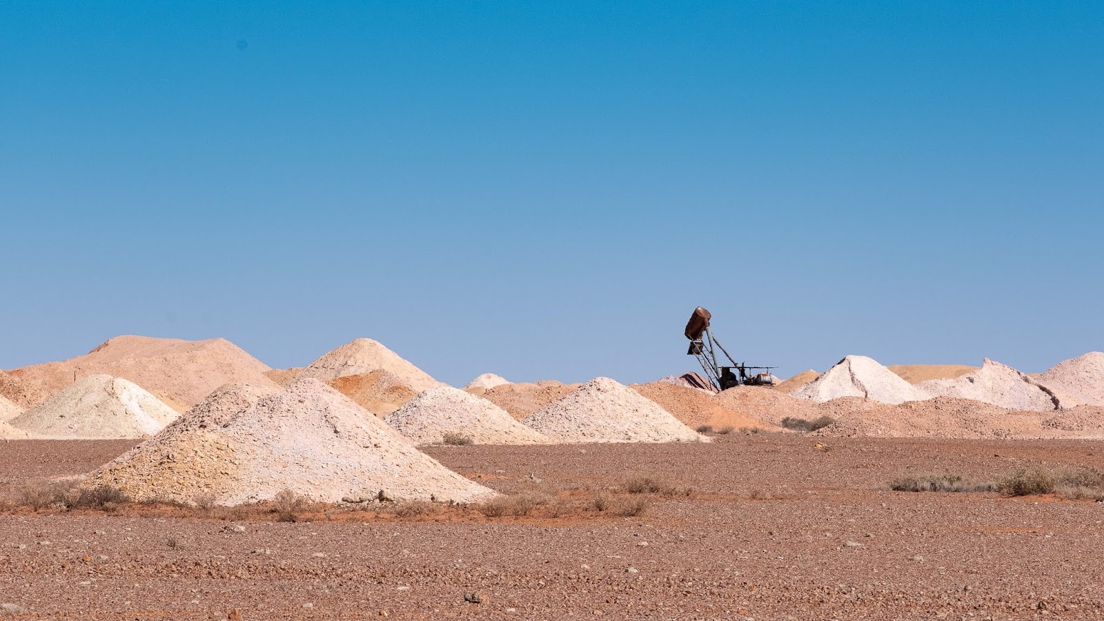 |
| Opal mining outside Coober Pedy |
 |
| Old style underground home... now there are underground hotels |
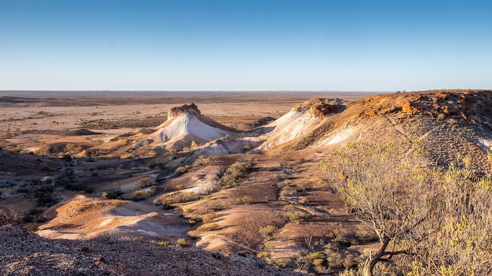
The town itself did not seem to have changed much from the last time we visited in 1989… just a tad larger but the real highlight for us was doing a 70km drive out to the Kanku-Breakaways Conservation Park for sunset.
We did a circuit drive to also have a look at the Dingo Fence, one of the longest structures in the world and stretching 5,614 kms.
 |
| THE dingo fence near Coober Pedy |
The views as we wandered through the park on its dirt tracks and then sunset were simply beautiful.
 |
| One of our first views of part of Kanku-Breakaways landscape |
 |
| More Breakaways scenery at sunset |
 |
| Sunset at the Breakaways |
After leaving Coober Pedy we made a lonely 165km drive on dirt roads east to the normally very small community of William Creek, located on the Oodnadatta Track to fulfil one of our long standing bucket list items.
William Creek’s normal population is 5… yes that’s right… 5 but currently on a daily basis there would be a few hundred people arriving/leaving William Creek to do what we had wanted to do, fly over the normally dry Lake Eyre salt lake when it is in flood.
 |
| William Creek from the air |
Lake Eyre is usually a dry salt lake but very seldom after major flooding events in the north of Australia, those flooding waters head inland and south towards Lake Eyre.
During our visit this year it was about 60% full with waters still flowing in, something which had not happened to this extent for 45 years apparently.
There are about 13 planes making daily flights to and around Lake Eyre from various destinations and after our first night camping near the pub, we took off on our 1hr flight with 2 other couples.
 |
| Our camp at William Creek |
 |
| Rob in the William Creek pub |
First part of our flight to the lake was at 760 metres over the red and highly patterned remote outback before descending to 150 metres once we had reached the lake.
 |
| Landscape we flew over just before reaching Lake Eyre |
It was quite a sight flying over the vast expanse of water contained within a salty shoreline bounded by the reddish outback stretching into the distance.


 |
| The views were simply stunning |
The drive north from William Creek along the Oodnadatta Track to the town of the same name included stopping at the longest single track bridge on the Old Ghan railway, before trying out an ‘Oodna burger’ in the iconic pink roadhouse.
 |
| Massive railway bridge on the Old Ghan railway track |

Then it was a rockier and more lonely dirt roads back west to reach the Painted Desert and an overnight stay at Arckaringa Station and its 2,745 square kms of property used for raising 2,100 head of cattle.
 |
| Painted Desert Arckaringa |
 |
| Sunrise over Arckaringa Station campground |
The surrounding scenery as we got closer to the Stuart Highway was highly varied and really quite beautiful when contrasted against the grey clouds above us.


 |
| Scenery on the way back to Stuart Highway from Arckaringa Station |
The Stuart Highway took us into Alice Springs in the heart of Australia and after re-stocking it was time to start our journey home via the East McDonnell Ranges with an overnight stay in Trephina Gorge after hiking above and through it.
 |
| View from the ridge around Trephina Gorge |
After visiting the Arltunga Historical Reserve, home to the first town in central Australia due to gold being found and once housing 300 people but now deserted, we joined the remote Binns Track and picked our way overland until we reached the Plenty Highway for our trip east towards home.
 |
| Some of the remains of gold mining township of Arltunga |
Now the title ‘Plenty Highway’ is a bit of an overstatement in that the first 150kms of the highway from the Stuart Highway is sealed and the remaining 550kms is dirt of varying corrugated, rocky or bulldust condition to Boulia in Queensland.
As usual, driving in this part of our country produces interesting experiences and a dust… a lot of dust. We came across and said “g’day” to a man driving a camel pulled wagon from Alice Springs to Taree in NSW and someone riding a pushbike across the Plenty from East to West.
 |
| Camel wagon on the Plenty Highway |
 |
| Yet another remote sunset |
 |
| Camping at Arthur River along the Plenty Highway |
Driving in the outback also means you get to do a lot waving to other travellers heading in the opposite direction. Usually it’s simply a 1 finger wave but sometimes we were greeted by usually passengers in a passing vehicle waving enthusiastically as if we were long lost friends.
We filled up at Jervois Station (cattle) about half way across before again free camping next to the dry Arthur River and enjoying another campfire before finally crossing into Qld and reaching Boulia starting to gear up for the camel races in a weeks time.
The rest of the drive home was fairly uneventful via towns like Winton, Longreach, Tambo of Tambo Bear fame and then Chinchilla, where we camped next to a weir for our last night on the road and final campfire before finally parking our trusty van at home and starting the big clean out of the dust we had collected during our 7 week trip.
 |
| Free camp near Boulia |
 |
| Last free camp and campfire at Chinchilla Weir before reaching home |
Being back out in the Australian bush was once again an amazing experience and something we never ever tire of.
Great read and sensational photos yet again, amazing landscapes out there. Thanks guys!!
ReplyDelete