This post covers the three other provinces we visited in eastern Canada, namely Prince Edward Island, New Brunswick and Nova Scotia and simply as a reminder, these provinces can be seen on the map below.
 |
| The 3 provinces of PEI, New Brunswick & Nova Scotia |
After disembarking the ferry at 6pm in Nth Sydney, Nova Scotia and having spent the night at another Walmart carpark, we then took back roads heading west through New Glasgow and stayed overnight in a campground at Pictou, more on this later.
 |
| Camping at Pictou and in sunshine for a change |
The following morning, it wasn’t very long before we finally reached ‘the bridge’ otherwise known as the Confederation Bridge, all 12.9 kms of it, one lane in either direction, taking us from the mainland to Prince Edward Island, another province of Canada.
 |
| Crossing the loooong Confederation Bridge to Prince Edward Island |
The Confederation Bridge was commenced in 1993, opened in 1997 and is the longest bridge in the world spanning ice covered water.
Prince Edward Island (PEI)
We were on PEI for only 3 nights and our actual routes throughout the island can be seen below.
 |
| Route around PEI including bridge crossing |
Almost as soon as we arrived we saw what generally the island is famous for… farming. There were farms pretty well everywhere and many of them quite large with massive sheds, big trucks and tractors. These farms generally didn’t seem to be doing it tough economically.
 |
| Few examples of farms on PEI |
 |
On PEI they bale their hay in rolls, put all the rolls in long lines and then
cover all of the rolls together to protect them from the weather |
During our visit, there were large numbers of trucks carting potatoes being harvested, one of the primary crops grown here, in part due to the very fertile soil PEI has which is red in colour, due to its very high iron content.
 |
| Potato carting truck on PEI |
The island is also renowned for its seafood, in particular lobster, mussels, scallops and oysters. During our drive throughout the island, we happened upon a group of boats bunched together using what looked like long handled rakes catching something in the river.
 |
| Fishermen at work together on PEI |
Locals later taught us they were ‘tonging’ for wild oysters on the river bed, the ‘tongs’ actually looking like 1m rake/scoop like heads at the end of handles ranging between 2-3 metres long.
 |
| Oyster 'tong' example - thanks to Google |
Something else we had to try on the island was a Lobster Supper at the venue which started these, and yes the lobsters was great. First you choose the size of lobster you want and then you have a choice of starters like chowder or mussels or both.
You can have as much of these as you want before the lobster arrives with an apron to wear, instructions on how to extract the meat and some tools. After all this there was a choice of deserts also.
 |
| First we we provided the 'how to' of eating lobster |
 |
| Getting ready to tuck into some fresh lobster |
PEI is also famous for being the home of Lucy Maud Montgomery who wrote the book ‘Anne of Green Gables’, so naturally it was almost obligatory to go see both her home and the farm of Green Gables, where Lucy spent time as a child and was the inspiration for her famous book.
 |
| THE green gables home of 'Anne of Green Gables' book fame |
 |
| Lucy Maud Montgomory's actual birth home |
There are many small communities scattered around PEI which only has a population of ~157,000 people and we drove through many of them following near the coastline with its red cliffs and yet more small lighthouses.
 |
| One of the many lighthouses on PEI |
Whilst having lunch in a small cafe, the owner told us a little more about living on the island during winter, and yes they can have a lot of snow, pushed around by strong winds blowing in off the ocean.
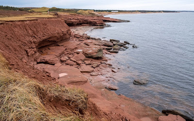 |
| Part of PEI's coastline and its red cliffs |
She recounted a time when they had 5+ metres of snow one winter where very strong winds also blew up a lot of red soil and the snow turned pink.
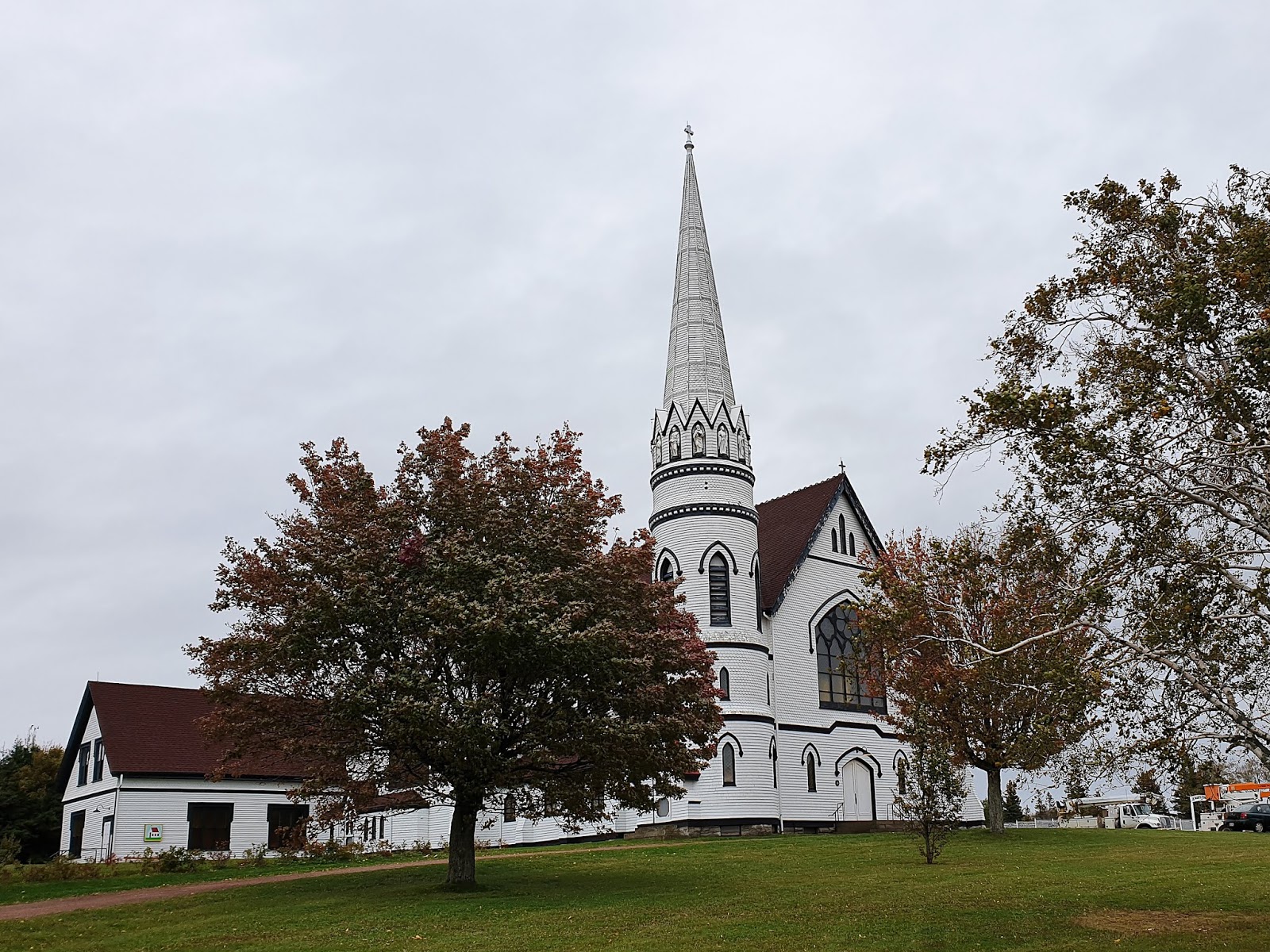
Something else PEI has plenty of churches of multiple denominations, again located across the island near those small communities.
 |
| There are a lot of churches on the island |
A Frenchman named Jacques Cartier, first founded PEI in 1534 and it was claimed by France who largely ignored it for 2 centuries and viewed it as excellent for farming. They named the island St Jean, but the British who took it from France then traded it back to France for a city in India.
Later, the British captured it again and deported 5,000 French and Arcadian settlers, the Arcadian being pastoralists wanting to live close to nature. Many Arcadians moved to Louisiana and became known eventually as Cajun, a play on their original Arcadian name.
So PEI had a bit of a strange start and became PEI in 1799 and evolved from then to the present, but after 2 days and looking at many farms and admiring some of the autumn colours beginning to erupt, we returned to ‘the bridge’ and crossed back to the mainland into New Brunswick.
 |
Nice to see the start of autumn colours
appearing whilst on PEI |
New Brunswick
In visiting this province we were again challenged with winterizing when it came to trying to find places to camp, so we had to make numerous phone calls to see which locations were still open.
It was also time to be re-acquainted with Canada’s interesting mixed language reality with frequent people answering our calls in French. Thankfully all of them spoke enough or plenty of English.
Our route through New Brunswick can be seen below and this province is home to ~800,000 people and is about 3% larger in physical size than Ireland but 83% of it is covered in trees and those trees were one of the reasons we were visiting. It was Autumn and the trees had already begun changing colour.
 |
| We managed to cover a fair bit of New Brunswick |
We chose to use a variety of scenic tourist driving routes throughout New Brunswick, each with their own names like Mountain, River, Coastal, Valley and Arcadian and we drove part of all of them.
New Brunswick’s main economic earners are agriculture, aquaculture and timber products. McCain Foods headquarters is also located in New Brunswick which pays testament to the provinces’ credentials in food production.
Back to this word Arcadian which in this part of the world refers to the original French settlers who worked the land in the provinces we were visiting.
As a result of a 6 colonial wars during the 17th & 18th centuries in what was known then as Arcadia, the British expelled thousands of people as a part of Britain wanting to ensure it had control and remove France’s influence. People of Arcadian descent register this by placing a star on their homes throughout New Brunswick.
 |
| A Arcadian star being proudly displayed on a home in New Brunswick |
Now if you boil it right down to the primary things we saw in New Brunswick it really comes down to 3-4 things. Tides and their effects, covered bridges, some nice little towns and autumn colours because of all the trees everywhere.
So lets start with the autumn colours which will involve maybe a few photos, they were just stunning and caused us to do many u-turns to go back and capture specific scenes.
As we drove the various scenic routes and headed further north then west within the province, the colours changed markedly from lots of very vivid reds, yellow, orange and burgundy colours near the coast in the south, predominately bright yellow and orange through the middle and finally, more dullish browns and yellows in the north west.
So here are a few photos of the range of autumn colours we experienced and at times it really did take our breath away. There are more photos in the link at the end of this post.
 |
| Few examples of a LOT of autumn colour opportunities |
New Brunswick lays claim to the longest covered bridge in the world at 390 metres, built in 1901 and as we walked across it, the wooden trusses were both large and in great condition, the reason they covered the bridges in the first place, to protect the wood.
 |
| The longest covered bridge in the world |
There are 58 covered bridges in New Brunswick and we managed to visit a few of them, all having been built between 1900 and 1920, some still being used and a few we could driver Homer2 through.
A few of the covered bridges happened also to be located in one of the few picturesque little towns we found, each town having its own unique character and buildings from bygone eras.
 |
| Some lovely older style homes in New Brunswick |
One of these towns, St Martins, had the lot with 2 covered bridges, small protected fishing harbour, a long beach and some sea caves to add to our sightseeing joy.
 |
| St Martins was a very pretty little town with a lot to offer |
 |
| It also had sea caves and a great place to stop for lunch |
We much preferred these small towns to New Brunswick’s capital, Saint John which had all the lack of feel of an industrial city, despite there being 2 cruise ships docking as we departed. Did try to see something called the Reversing Falls but the tides were all wrong.
As a bonus, we did manage to see the world’s largest axe in Nackawic, New Brunswick, standing 15 metres tall, weighing 55 tonnes with an axe head 7 metres wide made out stainless steel.
 |
| Yep... the world's largest axe |
The final part of our tour through New Brunswick was driving around the coastline of the Bay of Fundy, renowned as having the largest tides in the world with a tidal range of about 15 metres (49 ft) when the average tidal range worldwide is around 1 metre. The size of the tidal movement depends on the position of the moon, the sun, and atmospheric conditions.
 |
| Looking down along the Bay of Fundy's coastline |
The Fundy coastline is rugged and also subjected to a lot of fog as we discovered whilst visiting Cape Enrage where there was yet another lighthouse, this one built in 1840.
 |
| Cape Enrage's lighthouse and the coast it watches over |
At the viewing point located right where everyone stands is a large fog horn. The sign on it warns visitors that the horn could be sounded at anytime and without warning and would most likely cause permanent hearing damage. Great!
We stayed 2 nights in a near deserted campground near Hopewell Rocks, a National Park, which happened to have closed down for the season on the afternoon we arrived.
It’s here you get to see the full effect of the Fundy Bay tides by visiting some rock formations called The Flowerpots and the reason for staying 2 nights was to ensure we wouldn’t be messed up by tide times.
So we visited the same locations a few times to catch photos at low tide and then again at high tide as shown below. We also walked down onto the ocean floor amongst The Flowerpots to appreciate just how big the rock formations are and to put the tide movements into context.
 |
| Tide out at the Flowerpots... |
 |
| ...and the tide back in again |
 |
| Down amongst the Flowerpots... look carefully for Rob in arch of the photo above |
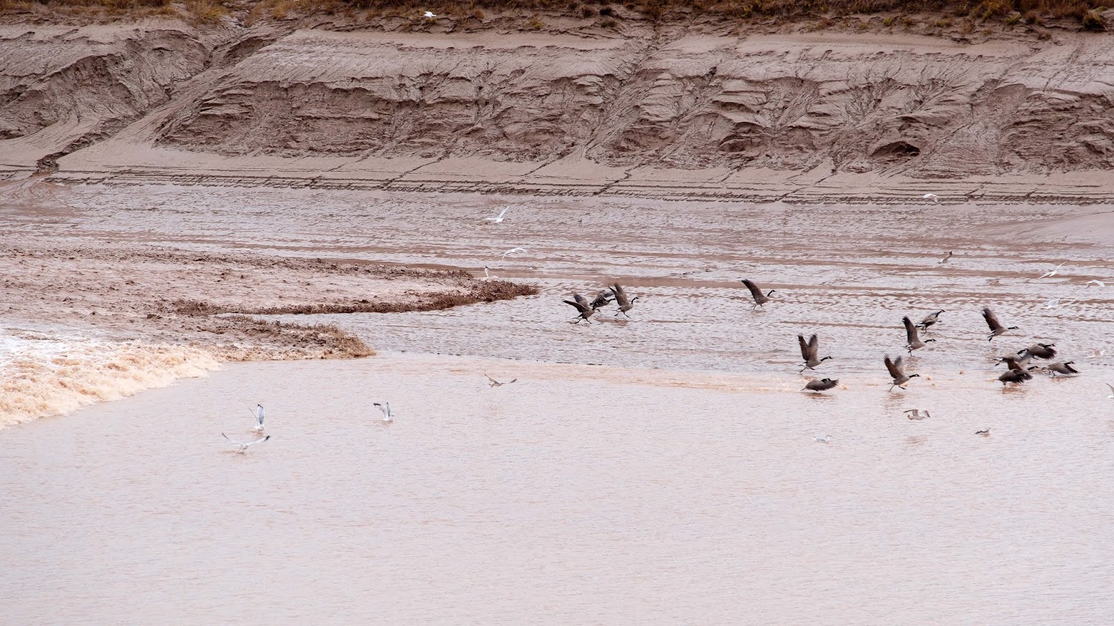
Our final display of tidal force before leaving New Brunswick was in the town of Moncton, by standing on an observation deck for the ‘Moncton Bore’. So there we stood looking at a very low muddy river winding its way to the bay about 15 minutes before the forecast event was to happen.
A small flock of Canadian Geese landing on the river in front of us, then casually started washing themselves.
 |
| The Canadian geese coming in to land |
Earlier than predicted and downstream from us we could see something happening in the water and it was heading towards us, a small looking wave moving upstream and at a fairly quick pace, splashing lots of water up the sides of the banks.
 |
| Here comes the tidal wave |
Soon the peaceful time for the geese had ended as the wave reached them, forcing them to madly start paddling upstream before taking off and departing.
 |
| Certainly disturbed the peace of the geese |
Then came the sound of the surging water as it passed by us, the Moncton Bores 30 cm wave leading the way. It was quite impressive and all caused by the huge Bay of Fundy tides making their way back up the ever narrowing rivers.
 |
| And there goes the Moncton Bore heading upstream |
So now and fairly briefly to the final province we visited in eastern Canada… Nova Scotia.
Nova Scotia
The reason for only a brief description of this province is because we had been here before in 2001 so had not planned to do things like drive out to Cape Breton again, certainly a very picturesque place to visit.
When we landed into Halifax, the capital of Nova Scotia for our 3 nights stay before heading to Newfoundland, we enjoyed clear skies and warm weather which made walking around the town very enjoyable, especially down along and through the port area.
 |
| Few scenes from around Halifax, Nova Scotia |
Some cruise ships were in town, so the city was buzzing with activity, people and everyone was in a jovial mood it seemed. Away from the port area, the laid back attitude of the people continued and the city seemed to have a feel similar to Portland in Oregon and the older timber houses around Halifax had a similar look in part to many of the older homes found around the bay area of San Fransisco.
They have quite a few boutique and casual cafes scattered around in and near the city and was a very relaxing way to enjoy some pleasant home cooked style food.
Whilst travelling from North Sydney to ‘the bridge’ on the way to PEI, we also stayed in a little town on the coast called Pictou which means ‘New Scotland’ in Latin. Both the small township was a delight to be in as was the campground run by a person who really cared about service.
 |
| In and around Pictou, Nova Scotia |
After cleaning Homer2 very thoroughly and handing it back over to Fraserway, we had the chance to reflect on our experiences whilst travelling through 4 different provinces of Canada and the 7,492 kms of driving involved before flying out that night to our next destination.
We know we won’t return here but we certainly learned there are a bunch of very resilient, friendly and good humoured people who call this part of the world home and were thankful they taught us a lot about living in eastern Canada.
Till the next post… go well!


No comments:
Post a Comment